
12 Best Map Apps for Road Closures in 2026: Free and Paid Apps Ranked
12 best map app for road closures picks compared on live closure data, offline maps and price. Most are free — see which app reroutes you fastest.
 Shamim Mia, Founder, SerpAstraLast verified November 2, 202611 min read
We compare pricing pages, documentation and public reviews. We never accept payment for rankings.
Key takeaways
- Waze is the fastest free alert for closures, followed by Google Maps and Apple Maps — all three are free, with no paid tier.
- The single most important buying factor is how fresh the closure data is: live reports beat downloaded maps, so pair a live app with an offline backup.
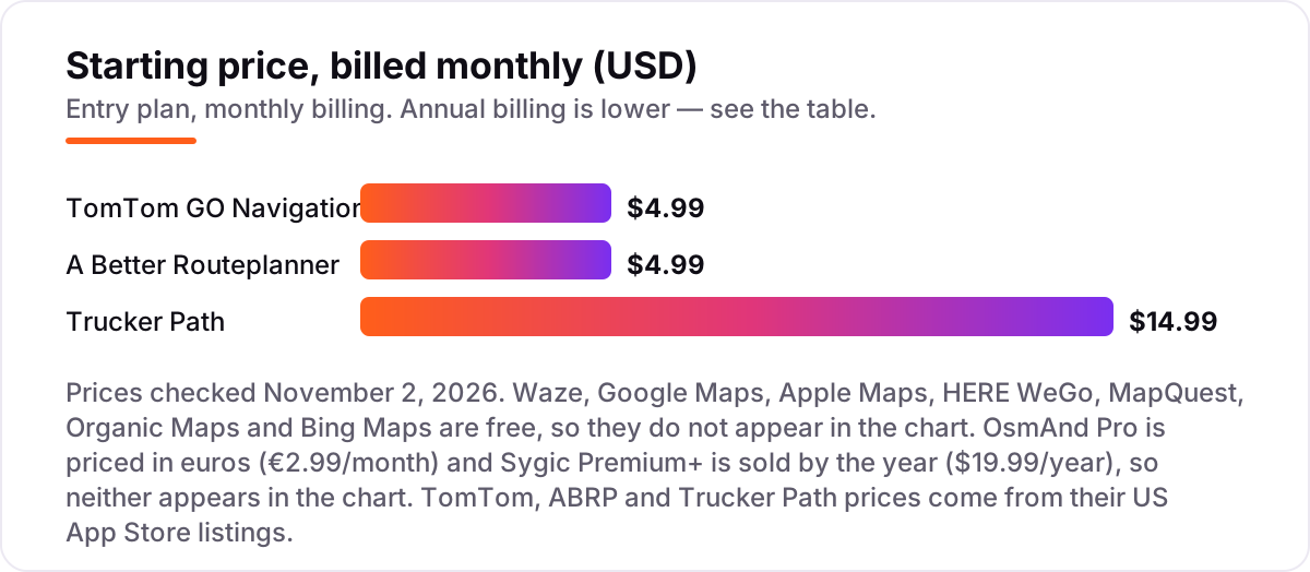
- Only three apps here charge a monthly fee — TomTom GO Navigation and A Better Routeplanner at $4.99 a month, and Trucker Path Gold at $14.99 — and Sygic Premium+ costs $19.99 a year.
- Every price below was checked on November 2, 2026. Free apps are free; paid-app prices come from US App Store listings or third-party sources, not vendor pricing pages, because these apps sell through app stores.
On this page
Quick comparison
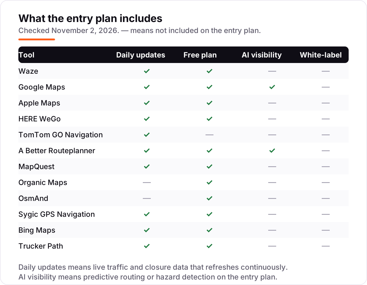
| Tool | Best for | Starting price | Free plan |
|---|---|---|---|
| Waze | Drivers who want the fastest warning about a closure ahead, reported by other drivers in real time | Free | Yes (free) |
| Google Maps | Everyday drivers who want closure alerts plus the most complete maps in one free app | Free | Yes (free) |
| Apple Maps | iPhone drivers who want closure alerts built into iOS, CarPlay and Siri | Free | Yes (free) |
| HERE WeGo | Drivers who need offline maps and closure-aware routing without a data connection | Free | Yes (free) |
| TomTom GO Navigation | Drivers who want TomTom traffic data and offline maps in a paid, ad-free app | $4.99/mo | No (7-day trial) |
| A Better Routeplanner | EV drivers who need closure-aware rerouting that also plans charging stops | $4.99/mo | Yes (free plan) |
| MapQuest | US drivers who want a free web-and-app map with live traffic and road-closure info | Free | Yes (free) |
| Organic Maps | Privacy-minded drivers and hikers who want free offline maps with no tracking | Free | Yes (free) |
| OsmAnd | Drivers and outdoor users who want deep offline maps with contour and Wikipedia layers | €2.99/mo | Yes (7 maps) |
| Sygic GPS Navigation | Drivers who want offline 3D maps with live traffic and speed-camera alerts | $19.99/yr | Yes (basic free) |
| Bing Maps | Drivers who want a free web map with live traffic incidents and closure info | Free | Yes (free) |
| Trucker Path | Truck drivers who need closures, low-clearance warnings and parking data on truck routes | $14.99/mo | Yes (basic free) |
Make one of these tools?
We re-check this list every quarter. Send a correction, request a review, or ask about a clearly labeled sponsored spot.
Request a listingThe best map app for road closures

Waze
Best for: Drivers who want the fastest warning about a closure ahead, reported by other drivers in real time
Waze is the quickest way to hear about a closure because the report comes from a driver who just hit it. The app is free, and every driver on the road is a sensor: a closure, a crash, a hazard or a police stop gets flagged within minutes, and the route updates for everyone behind. That speed is what makes it the top pick for road closures rather than just for traffic in general.
The catch is that Waze needs a connection and other drivers. In a city at rush hour the reports are constant; on a quiet rural road at night there may be nobody ahead of you to report the fallen tree. It also shows ads and has no offline maps, so a dead zone leaves you with the last downloaded route.
What we like
- Crowdsourced closure, hazard and police reports arrive within minutes of the event
- Reroutes automatically around a reported closure instead of waiting for the next refresh
- Free with no paid tier, and works with CarPlay and Android Auto
- ETA estimates draw on live speeds from other drivers on the same roads
Watch out for
- Shows ads on the map, and heavy use drains battery and mobile data
- No offline maps, so it stops helping when the signal drops
- Report quality depends on how many Waze drivers are nearby

Google Maps
Best for: Everyday drivers who want closure alerts plus the most complete maps in one free app
Google Maps is the safe default because it does almost everything well and costs nothing. Live traffic and incident reports cover closures on most roads, offline maps keep you moving without a signal, and the place database is the largest in this list. Predictive ETAs and AI-powered route suggestions are included on the free plan, and it works the same on Android, iPhone and the web.
The weakness is depth, not breadth. Google Maps has no dedicated closure feed, so a closure can sit inside a generic incident report with little detail about how long it will last or which lanes are shut. Its reports are also less chatty than Waze, with fewer driver comments. If you want the richest closure detail, run Waze alongside it; if you want one app that never lets you down, this is it.
What we like
- Live traffic and incident reports cover closures on most roads in most countries
- Downloadable offline maps keep routing working without a signal
- The largest place database here, with hours, reviews and photos built in
- Predictive ETAs and AI-powered route suggestions on the free plan
Watch out for
- No dedicated closure feed, so a closure can sit inside a generic incident report
- Closure reports are less detailed than Waze, with fewer driver comments
- Needs a Google account for saved places and full history

Apple Maps
Best for: iPhone drivers who want closure alerts built into iOS, CarPlay and Siri
Apple Maps has closed the gap with Google Maps in the last few years, and for iPhone owners it is now a genuine first choice. Incident reports include road closures, hazards and accidents, shown directly on the route, and offline maps in iOS mean the app keeps working when the signal drops. It is built into iOS, CarPlay, Siri and Apple Watch, so there is nothing to install and nothing to pay.
The limits are platform and crowd. Apple Maps only runs on iPhone, so an Android driver in the household needs a different app, and on quieter roads there are fewer crowdsourced reports than Waze collects. Some features, such as detailed city maps, also vary by region. For a driver already inside the Apple ecosystem, though, it is the most convenient free option here.
What we like
- Incident reports include road closures, hazards and accidents, shown on the route
- Built into iOS, CarPlay, Siri and Apple Watch with no extra app to install
- Offline maps in iOS keep navigation working without a connection
- Apple collects less location data than the ad-supported alternatives
Watch out for
- iPhone only, so Android drivers in the household need another app
- Fewer crowdsourced reports than Waze on quieter roads
- Some features, such as detailed city maps, vary by region

HERE WeGo
Best for: Drivers who need offline maps and closure-aware routing without a data connection
HERE WeGo is the best free choice when the signal cannot be trusted, because the whole map lives on the phone. Download a country once and you get turn-by-turn navigation, live traffic when you are online, and routing for car, transit, walking and cycling, all without an account and without ads in the navigation view. That makes it a strong pick for rural driving and for travel abroad.
The trade-off is the size of the crowd behind it. HERE WeGo has fewer crowdsourced closure reports than Waze or Google Maps, so a fresh closure on a minor road may appear later here than there. The interface also feels less polished, and place data is thinner outside major cities. Use it as your offline backup, or as your main app if you drive where coverage is patchy.
What we like
- Full offline maps for whole countries, downloaded once and used without a signal
- Live traffic and incident data when online, with rerouting around closures
- No account or sign-in needed, and no ads in the navigation view
- Covers car, public transit, walking and cycling in one free app
Watch out for
- Fewer crowdsourced closure reports than Waze or Google Maps
- The interface feels less polished than the big two
- Place data is thinner than Google Maps outside major cities

TomTom GO Navigation
Best for: Drivers who want TomTom traffic data and offline maps in a paid, ad-free app
TomTom GO Navigation is the paid, ad-free alternative for drivers who trust TomTom data more than crowdsourced reports. The Car plan costs $4.99 a month and includes TomTom Traffic, speed-camera alerts, lane guidance and full offline maps, with a 7-day free trial that covers the whole feature set. TomTom does not monetise personal driving data, and there are no ads in the navigation view.
The honest question is whether it is worth paying for when Waze and Google Maps are free. TomTom's closure reports are thinner than the crowdsourced apps, and the subscription is sold through the app stores rather than on TomTom's own pricing page, so the price can vary by store and region. It suits drivers who want a clean, ad-free navigator with reliable offline maps and are happy to pay $4.99 a month for it.
What we like
- TomTom Traffic data with speed-camera alerts and lane guidance on every route
- Full offline maps, so closures already on the map stay visible without a signal
- Ad-free, and TomTom does not monetise personal driving data
- A 7-day free trial covers the full feature set before you pay
Watch out for
- Paid after the trial, while Waze and Google Maps offer the same basics free
- Closure reports are thinner than the crowdsourced apps
- Subscriptions are sold through the app stores, not on TomTom's own pricing page

A Better Routeplanner
Best for: EV drivers who need closure-aware rerouting that also plans charging stops
A Better Routeplanner, known as ABRP, is the only app here built for electric cars, and closures matter more in an EV because a detour can change where you need to charge. The free plan covers route planning for more than 1,000 EV models, and Premium at $4.99 a month adds live traffic, weather, CarPlay and Android Auto, plus live vehicle data and automatic rerouting when conditions change.
The catch is that live traffic is a Premium feature, so the free plan cannot reroute you around a closure on its own. The interface is also dense, and setting up your car model, consumption and charger preferences takes time before the first trip. For EV drivers who plan long journeys, though, no other app here combines closure-aware rerouting with charging-stop planning, which is why it earns its place.
What we like
- Live traffic and automatic rerouting on Premium, with weather factored into the route
- Plans charging stops around closures and detours, using live vehicle data
- CarPlay and Android Auto support on Premium for in-car use
- Covers more than 1,000 EV models with real-world consumption data
Watch out for
- Built for EVs, so petrol and diesel drivers get little from it
- Live traffic is a Premium feature, not in the free plan
- The interface is dense and takes time to set up properly

MapQuest
Best for: US drivers who want a free web-and-app map with live traffic and road-closure info
MapQuest is the quiet free option that many US drivers overlook. It is free on the web and on iOS and Android, with live traffic and incident reports that include closures, multi-stop route planning, gas prices along the way and turn-by-turn voice navigation. There is no account to create and no fee to pay, which makes it an easy second app to keep on the phone.
The limits are crowd size and polish. MapQuest has fewer crowdsourced reports than Waze, so a closure on a quiet road updates more slowly, and the app feels less refined than Google Maps or Apple Maps. Coverage and place data are also strongest in the US and thinner elsewhere. As a free backup to a main navigator, though, it is hard to fault.
What we like
- Live traffic and incident reports, including closures, on the free plan
- Free with no account, and works on the web as well as on iOS and Android
- Multi-stop route planning with gas prices along the way
- Turn-by-turn voice navigation with lane guidance
Watch out for
- Fewer crowdsourced reports than Waze, so quiet roads update slowly
- The app feels less polished than Google Maps or Apple Maps
- Coverage and place data are strongest in the US, thinner elsewhere

Organic Maps
Best for: Privacy-minded drivers and hikers who want free offline maps with no tracking
Organic Maps is the privacy pick in this list: a free, open-source app that puts the whole world's maps on your phone and tracks nothing. There are no ads, no account and no location data leaving the device, and the maps cover car, cycling and hiking routes with contour lines and trails. It is built on OpenStreetMap data, and it works entirely offline once the maps are downloaded.
The trade-off is built into the design. Because it works offline, there are no live traffic or closure reports at all, so a road closed this morning will not appear unless the map data already knows about it. Routing is also less refined than the big navigation apps, and a small team ships updates more slowly. Use it where privacy and offline access matter most, not as your only closure alert.
What we like
- Fully offline maps for the whole world, downloaded once and used anywhere
- No ads, no account and no location tracking, as an open-source app
- Detailed hiking and cycling maps with contour lines and trails
- Bookmarks and saved routes work without any cloud sync
Watch out for
- No live traffic or closure reports, since it works offline by design
- Routing is less refined than the big navigation apps
- A small team ships updates more slowly than Google or Apple

OsmAnd
Best for: Drivers and outdoor users who want deep offline maps with contour and Wikipedia layers
OsmAnd is the offline specialist, built on OpenStreetMap data with a depth of map detail no other app here matches. The free app lets you download 7 maps, and OsmAnd Pro at €2.99 a month removes the limit, adds hourly map refreshes, a 3D view, contour lines, terrain shading, Wikipedia places and nautical maps, plus CarPlay and Android Auto. Route planning can respect vehicle size and road preferences.
What it cannot do is tell you about a closure that happened ten minutes ago, because there is no live traffic feed: maps are the product, not live data. The interface is also complex and takes a while to learn, and the free cap of 7 maps means regular travellers need Pro. For drivers who go where the signal does not, OsmAnd is the most capable offline map in this list.
What we like
- Unlimited offline map downloads on Pro, with hourly map refreshes
- Rich layers: contour lines, terrain shading, Wikipedia places and nautical maps
- CarPlay and Android Auto support on the paid plans
- Route planning that respects vehicle size and road preferences
Watch out for
- No live traffic or closure alerts, since maps are the product, not live data
- The interface is complex and takes a while to learn
- The free app caps downloads at 7 maps, so regular travellers need Pro

Sygic GPS Navigation
Best for: Drivers who want offline 3D maps with live traffic and speed-camera alerts
Sygic GPS Navigation is the cheapest paid upgrade in this list: Premium+ costs $19.99 a year and adds real-time traffic, speed-camera alerts, lane guidance and CarPlay and Android Auto to a free app with offline 3D maps. Sygic updates its maps multiple times a year, free on every plan, and the head-up display mode projects directions onto the windscreen at night.
The catch is that live traffic is paid, so the free app cannot reroute you around a closure on its own. Prices and licence terms also vary by region and by app store, and some features, such as dashcam tools, are sold as add-ons rather than included. For drivers who want offline maps plus live closure data for about $20 a year, though, Sygic is the best value paid option here.
What we like
- Offline maps that Sygic updates multiple times a year, free on every plan
- Real-time traffic and speed-camera alerts on Premium+, with lane guidance
- CarPlay and Android Auto support, plus a head-up display mode
- Premium+ costs $19.99 a year, the cheapest paid plan in this list
Watch out for
- Live traffic is paid, so the free app cannot reroute around a closure
- Prices and licence terms vary by region and by app store
- Some features, such as dashcam tools, are sold as add-ons

Bing Maps
Best for: Drivers who want a free web map with live traffic incidents and closure info
Bing Maps is the best free option that needs no app at all. Open it in any desktop or mobile browser and you get live traffic and incident reports, including closures, route planning with traffic-aware ETAs and Streetside imagery that helps you recognise a closed junction before you drive it. There is nothing to install and nothing to pay.
The limits are that it is a browser tab, not a navigator. There is no dedicated mobile app, turn-by-turn guidance is less detailed than the app-first tools, and there are far fewer driver reports than Waze or Google Maps collect. It works best as a quick check before you leave, or as the map on a second screen, rather than as your only guide on the road.
What we like
- Live traffic and incident reports, including closures, free on the web
- Nothing to install, and it works on any desktop or mobile browser
- Streetside imagery helps you recognise a closed junction before you drive it
- Route planning with traffic-aware ETAs at no cost
Watch out for
- No dedicated mobile app, so it is a browser tab rather than a navigator
- Far fewer driver reports than Waze or Google Maps
- Turn-by-turn guidance is less detailed than the app-first tools

Trucker Path
Best for: Truck drivers who need closures, low-clearance warnings and parking data on truck routes
Trucker Path is the only app here built for truck drivers, and closures matter more in a truck because a wrong turn can mean a low bridge or a road your vehicle is not allowed on. Gold at $14.99 a month adds truck navigation, parking predictions, offline maps and fuel prices to free basics that already cover truck stops, weigh stations and fuel. Routing respects height, weight and hazmat restrictions.
The price is the highest in this list, and the routing is truck-only, so it is no use in a car. App-store reviewers also report that cancelling a subscription can be difficult, so set a reminder if you start a trial. For a professional driver whose route depends on closures and restrictions, though, the truck-specific data is worth more than the free car apps can offer.
What we like
- Truck routing that respects height, weight and hazmat restrictions
- Parking availability and predictions at truck stops, with fuel prices
- Closure and incident data on the truck network, with offline maps on Gold
- Free basic features cover truck stops, weigh stations and fuel
Watch out for
- The priciest app here at $14.99 a month for Gold
- Truck-only routing, so it is no use in a car
- App-store reviewers report that cancelling a subscription can be difficult
If a road is closed, the best map app for road closures is the one that tells you before you reach the barrier, not after. This list ranks 12 free and paid apps by how fast they surface closures, how well they reroute you, and whether they keep working when the signal drops.
How to choose the best map app for road closures
- Closure speed. How fast does a closure appear after it happens? Crowdsourced apps show it in minutes; downloaded maps may not show it until the next update.
- Rerouting. Does the app route around the closure on its own, or does it just show a red line and leave the detour to you?
- Offline maps. If you drive through dead zones, downloaded maps matter more than any live feature.
- Coverage where you drive. Crowdsourced apps are strongest in cities, so check whether your regular roads have enough reporters.
- Price. Seven of the 12 apps here are free, so pay only when the paid features solve a problem the free apps do not.
If you run a local business, a closure on the road outside your door still sends customers to your listing, so staying visible on the map matters as much as the drive itself. Our monthly SEO service keeps your business showing up when drivers search nearby, and the free Google review link generator helps you collect the reviews that keep you in the map pack. For a broader view of the tools local businesses use to show up on maps, see our list of the best local SEO tools, the guide to what local SEO is, and how to rank in the map pack.
Map app for road closures pricing: what you will actually pay
Seven of the 12 apps here cost nothing at all, and that includes the three best closure alerts: Waze, Google Maps and Apple Maps. A car commuter can pay $0 and still get live closure reports, automatic rerouting and offline maps. The paid plans only start to matter when you need something specific: an EV driver who wants live traffic in A Better Routeplanner pays $4.99 a month for Premium, and a driver who wants TomTom GO Navigation pays $4.99 a month for the Car plan. A truck driver who needs Trucker Path Gold pays $14.99 a month, the highest price in this list.
If one driver bought all three monthly plans, the total would be $24.97 a month, but nobody needs all three, because each one serves a different driver. The two yearly options are cheaper still: Sygic Premium+ is $19.99 a year, and OsmAnd Pro is priced in euros at €2.99 a month, or €29.99 a year. So the honest answer for most drivers is $0 a month, for an EV driver $4.99 a month, and for a truck driver $14.99 a month.
Know the difference: crowdsourced closure reports vs official closure data vs offline maps
Closure information comes from three places, and no single app has all three at their best. Crowdsourced reports come from drivers: Waze is the purest example, and a closure reported by the driver ahead of you can reach your phone within minutes. The weakness is coverage, because a quiet road with few drivers produces few reports. Official closure data comes from road agencies and departments of transportation: Google Maps, Apple Maps and HERE WeGo blend it in, so a planned closure can appear before it starts, with a start and end time. The weakness is speed, because an unplanned closure has to travel from the agency to the map.
Offline maps are the third kind, and they are not live data at all. OsmAnd, Organic Maps and the offline modes of Google Maps and Apple Maps show the closures that were already in the downloaded map data, and nothing newer. That is still useful: a closure that has been in place for a week will be in the download, and the map works with no signal at all. The mistake is to treat an offline map as a live alert. The strongest setup pairs a live app, such as Waze or Google Maps, with an offline backup, such as HERE WeGo, so a closure is caught fast and the route survives a dead zone.
Quick comparison: tool type by need
| Buyer | Best pick | Why |
|---|---|---|
| Everyday commuter | Waze | Fastest closure alerts from other drivers, free |
| One-app driver | Google Maps | Closures, offline maps and places in one free app |
| iPhone driver | Apple Maps | Closures built into iOS and CarPlay, free |
| No-signal driving | HERE WeGo or OsmAnd | Full offline maps; HERE adds live traffic when online |
| EV driver | A Better Routeplanner | Closure rerouting plus charging-stop planning |
| Truck driver | Trucker Path | Closures and restrictions on truck routes |
How we chose
We checked each app's own site or app-store listing on November 2, 2026 and recorded the starting price exactly as shown, with free apps listed as free. TomTom GO Navigation, A Better Routeplanner and Trucker Path sell their subscriptions through the app stores, so their prices come from their US App Store listings rather than a vendor pricing page; Sygic Premium+ at $19.99 a year and OsmAnd Pro at €2.99 a month come from third-party reviews, since neither vendor publishes a simple pricing page. No G2, Capterra or Trustpilot rating exists for these consumer map apps, so no ratings are shown. We ranked the apps by fit for the most common buyer, an everyday driver who wants to know about a closure before reaching it, not by brand size. No vendor paid for a place in this list, and none of the links here are affiliate links.
What to do next
Start with Waze and Google Maps. Both are free, and together they cover fast closure alerts and reliable offline routing, which is the combination most drivers need. Add HERE WeGo if you drive through dead zones, and try the 7-day trial of TomTom or Trucker Path only if the free apps miss something you need. Check the comparison table above against the roads you actually drive, then install your top pick before the next trip. Once your tools are in place, find out what's holding your rankings back.
Your stack only works if people find you
SerpAstra fixes what keeps your site off page one and makes it easy for AI assistants to recommend.
Get a free audit→Sources we checked (15)
- Waze — waze.com (free app; checked November 2, 2026)
- Google Maps — maps.google.com (free app; checked November 2, 2026)
- Apple Maps — maps.apple.com (free app; checked November 2, 2026)
- HERE WeGo — wego.here.com (free app; checked November 2, 2026)
- TomTom GO Navigation — tomtom.com app page; Car 1 month $4.99 from the US App Store listing (checked November 2, 2026)
- A Better Routeplanner Premium — US App Store listing, Monthly $4.99, Annually $49.99 (checked November 2, 2026)
- MapQuest — mapquest.com (free app; checked November 2, 2026)
- Organic Maps — organicmaps.app (free app; checked November 2, 2026)
- OsmAnd Pro €2.99/month — Backdrop Journal review (checked November 2, 2026)
- OsmAnd — osmand.net (free app, 7 map downloads; checked November 2, 2026)
- Sygic Premium+ $19.99/year — PinDropApps review (checked November 2, 2026)
- Sygic GPS Navigation — Google Play listing, maps updated multiple times a year (checked November 2, 2026)
- Bing Maps — bing.com/maps (free; checked November 2, 2026)
- Trucker Path Gold $14.99/month — Highway Miles comparison of US App Store prices, October 10, 2026 (checked November 2, 2026)
- Trucker Path fleet pricing — truckerpath.com/pricing (checked November 2, 2026)
Shamim
Founder of SerpAstra
A full-stack SEO and digital marketer who spends most days on Local SEO for dental practices, AI search visibility and lead generation.
Frequently asked questions
What is the best map app for road closures?
Waze is the best for most drivers, because closures are reported by drivers who just passed them, so alerts arrive within minutes. Google Maps is the best all-rounder, with closure reports, offline maps and the largest place database in one free app. Apple Maps is the best pick if you drive an iPhone.
Is there a free map app that shows road closures?
Yes, several. Waze, Google Maps, Apple Maps, HERE WeGo, MapQuest, Organic Maps and Bing Maps are all free and show closures or incidents. Waze gives the fastest alerts, Google Maps gives the most complete picture, and HERE WeGo adds full offline maps. You do not need to pay anything to avoid a closed road.
Do map apps show official road closures or only driver reports?
Both, depending on the app. Google Maps, Apple Maps and HERE WeGo combine official road-agency data with user reports, so a planned closure appears before it starts. Waze leans on driver reports, which are faster for sudden closures but thinner on quiet roads. The best approach is to run one app from each camp.
Can I see road closures offline?
Only partly. Offline maps from Google Maps, Apple Maps, HERE WeGo, OsmAnd and Organic Maps show closures that were already in the downloaded map data, but they cannot report a closure that happened after the download. For fresh closure alerts you need a live connection, so download maps before a trip through a dead zone.
What is the best map app for truck drivers for road closures?
Trucker Path is the best pick for truck drivers. Its Gold plan costs $14.99 a month and adds truck navigation with parking predictions, offline maps and fuel prices to free basics covering truck stops and weigh stations. Routing respects height, weight and hazmat restrictions, so a closure detour will not send a truck down an unsuitable road.
How much does a map app for road closures cost?
Most cost nothing: seven of the 12 apps here are completely free. The paid options are TomTom GO Navigation at $4.99 a month, A Better Routeplanner Premium at $4.99 a month, Trucker Path Gold at $14.99 a month, Sygic Premium+ at $19.99 a year and OsmAnd Pro at €2.99 a month. A typical car driver can pay $0 and still get live closure alerts.
Waze vs Google Maps: which is better for road closures?
Waze is better for speed: its drivers report a closure within minutes, and it reroutes you at once. Google Maps is better for completeness: it pairs official closure data with user reports, adds offline maps and covers more roads. Many drivers run both, using Waze for alerts on the road and Google Maps for planning and places.
Free SEO and AI visibility audit
Find out what is holding your rankings back
Send us your site. Within 2 business days you get a written audit, an AI visibility check and a short fix list ranked by impact. Free, with no contract attached.
Request my free audit→Related guides
 Local SEOHow to rank in the Google map packHow Google picks the three map pack results: relevance, distance and prominence explained, plus the practical steps that move a local business up the list.Read guide →
 SEO & AI SearchBest Local SEO Tools for 2026: 11 Picks Ranked by What You Need11 best local SEO tools with real prices checked November 1, 2026 — from $14/month trackers to quote-only enterprise platforms, sorted by what you need.Read guide →
 Local SEOWhat is local SEO? A beginner's guide for small businessesWhat is local SEO? A clear beginner’s guide: how the map pack works, the five pillars, what it costs, and the first steps any small business can take.Read guide →