Best Apps for Crop Monitoring (2026): 7 Apps Worth Downloading
Compare the 7 best apps for crop monitoring on price, imagery, sensors and AI features, with every price checked November 6, 2026. Start free where you can.
 Shamim Mia, Founder, SerpAstraLast verified November 6, 202613 min read
We compare pricing pages, documentation and public reviews. We never accept payment for rankings.
Key takeaways
- OneSoil is free and the best place to start; Climate FieldView Plus starts at $499 a year, Agworld Basic at $1,495 a year and Pix4Dfields at $1,990 a year, while Taranis and CropX are custom-quoted.
- The single most important buying factor is the data source: satellite views cover whole farms cheaply, drone imagery catches leaf-level problems, and soil sensors answer irrigation questions — no single source does all three.
- Only two tools here carry a public review rating — Climate FieldView at 4.5/5 and Agworld at 4.7/5, both from just 3 G2 reviews — so treat ratings as a weak signal and trial the app on one field first.
- Free does not mean complete: the free plans cover monitoring only, and the real system cost sits in sensors, drone flights and dealer hardware.
On this page
Quick comparison
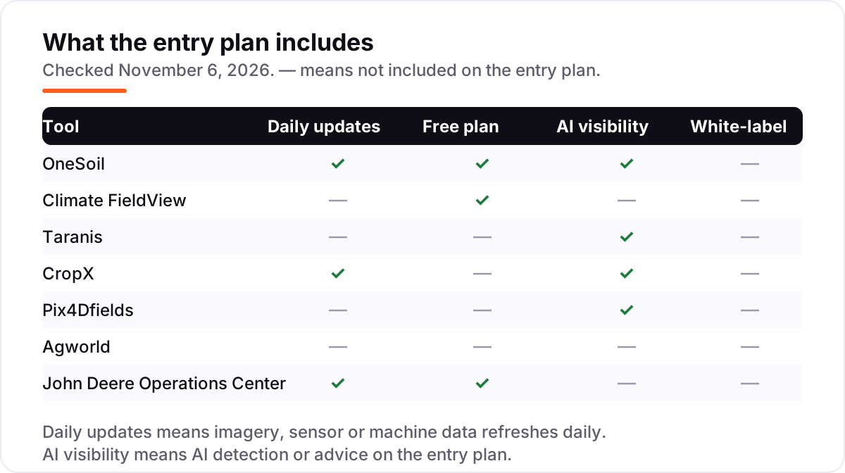
| Tool | Best for | Starting price | Free plan |
|---|---|---|---|
| OneSoil | Growers who want free satellite field monitoring with a daily AI agronomist before spending anything | Free | Yes (free app) |
| Climate FieldView | US row-crop growers who want machine data, satellite imagery and partner tools in one connected platform | $499/yr | Yes (free Trial) |
| Taranis | Large row-crop operations and advisors who want leaf-level AI detection of weeds, insects, disease and nutrient stress | Custom quote | No |
| CropX | Irrigated growers who want soil sensors to tell them exactly when, where and how much to water | Custom quote | No |
| Pix4Dfields | Growers and agronomists who fly their own drone and want fast in-field maps, vegetation indices and prescription maps | $1,990/yr | No |
| Agworld | Cropping teams who work with an agronomist and want plans, spray records, budgets and compliance in one shared record | $1,495/yr | No (7-day trial) |
| John Deere Operations Center | Farms already running John Deere equipment who want machine and field data in one free account | Free | Yes (free) |
Make one of these tools?
We re-check this list every quarter. Send a correction, request a review, or ask about a clearly labeled sponsored spot.
Request a listingThe best apps for crop monitoring

OneSoil
Best for: Growers who want free satellite field monitoring with a daily AI agronomist before spending anything
OneSoil is the cheapest way into crop monitoring because the core app costs nothing: add your fields, open the latest cloud-free satellite image, check basic field weather and log scouting notes from your phone. The AI Agronomist reads every field daily, cross-referencing satellite signals, weather and the crop calendar, then hands you one ranked list of what needs attention today instead of a map you have to interpret yourself.
The catch is resolution. Satellite views show vegetation zones and trends well, but they cannot match drone imagery for leaf-level problems such as early disease or insect damage, and cloud cover can delay a fresh image. Pro adds variable-rate maps built from up to seven years of satellite history, priced per hectare on request. Start here when the farm is large, the budget is zero and scouting priorities are the job.
What we like
- The core Scouting app is free: add fields, view the latest cloud-free satellite image and log scouting notes at $0
- The AI Agronomist reads every field every day and ranks what needs attention first
- Used by more than 140,000 farmers across 180 countries, per OneSoil, so the satellite coverage is proven at scale
- Variable-rate application maps come from up to seven years of satellite history, not a single season
Watch out for
- Satellite resolution is coarser than drone imagery, so early leaf-level disease can be missed
- Pro pricing is per hectare and not published on OneSoil's own site, so larger farms must ask for a quote
- Cloud cover can delay fresh imagery, and the app needs a signal in the field to sync notes

Climate FieldView
Best for: US row-crop growers who want machine data, satellite imagery and partner tools in one connected platform
Climate FieldView from Bayer is the connected choice: machine data streams in through FieldView Drive, satellite imagery and yield analysis layer on top, and more than 60 partners plug into the same account. The Trial plan costs $0 a year and covers data collection, storage and basic field mapping, while Plus starts at $499 a year and adds field health imagery, scouting reports, data analysis and zone management scripting.
The price to watch is the hardware. FieldView Drive is a separate purchase, and the subscription is annual, so the $499 figure is a yearly commitment rather than a monthly one you can cancel after harvest. The platform runs on more than 220 million subscribed acres, which means most dealers and agronomists already know it. Pick FieldView when the farm runs mixed equipment and one account is worth paying for.
What we like
- The most connected platform here, with more than 60 partners and compatibility with most equipment types
- Trial plan is free at $0 a year, so the mapping and data tools can be tried before paying
- Seed and nitrogen scripting turns field data into variable-rate plans in the same app
- Runs on more than 220 million subscribed acres globally, per Bayer, so dealer and agronomist support is easy to find
Watch out for
- The entry price is an annual subscription, so there is no month-to-month option at the $499 starting figure
- Machine data needs FieldView Drive hardware, which is a separate purchase
- Only 3 G2 reviews sit behind the 4.5/5 rating, so it is a thin signal

Taranis
Best for: Large row-crop operations and advisors who want leaf-level AI detection of weeds, insects, disease and nutrient stress
Taranis is the deepest detection in this list. Drones photograph every acre at submillimeter resolution, and the AI reads those images for stand counts, weed severity, insect damage, nutrient deficiency and disease pressure, trained on 500 million-plus leaf-level images. The Yield Impact model turns each threat into an estimated yield loss in bushels per acre, so a grower can weigh treatment cost against expected loss.
The trade-off is that Taranis is a service, not software you buy and run yourself. Pricing is custom-quoted per acre by service plan, coverage depends on the service area, and the model is built around crop advisors rather than solo growers. A May 2026 partnership with Syngenta extends leaf-level intelligence to precision agronomy at plant level. Choose Taranis when early detection on high-value acres is worth a quoted service price.
What we like
- Submillimeter drone imagery of every acre catches threats at leaf level, earlier than satellite views
- AI detects stand counts, weed severity, insect damage, nutrient deficiency and disease pressure
- Yield Impact turns each detected threat into an estimated yield loss in bushels per acre
- Ag Assistant is a generative AI agronomy engine that turns detections into management decisions
Watch out for
- No starting price is published, so budgeting starts with a sales conversation, not a number
- Drone imagery coverage depends on the service area, and not every region is flown
- Advisor-focused service model, so a solo grower buys through an advisor rather than self-serve

CropX
Best for: Irrigated growers who want soil sensors to tell them exactly when, where and how much to water
CropX answers a different question from the imagery tools: not what the crop looks like, but what the soil holds. Screw-in sensors report moisture, temperature and electrical conductivity from the root zone, and the platform turns those readings into irrigation schedules and disease risk forecasts across more than 80 crop types. With over 15,000 sensor deployments globally, it is the most proven sensor system in this list.
The cost structure is hardware plus subscription, both priced per sensor, and neither figure is published, so budgeting starts with a quote. Sensor placement matters: a probe in the wrong spot reports the wrong field, and installing across many fields takes a day of planning. Pick CropX when irrigation is the biggest cost on the farm and watering only when the soil needs it pays back fastest.
What we like
- Soil sensors report moisture, temperature and conductivity from the root zone, not from above the canopy
- Disease risk forecasts and irrigation scheduling help growers water only when the soil needs it
- Covers more than 80 crop types with over 15,000 sensor deployments globally, per CropX
- More than 180 integrations connect sensor data to irrigation systems and farm platforms
Watch out for
- No starting price is published, so the bill starts with a quote, not a list price
- Sensors are bought per unit on top of the subscription, so the hardware bill grows with field count
- Installing sensors across many fields takes planning, and placement mistakes skew the readings

Pix4Dfields
Best for: Growers and agronomists who fly their own drone and want fast in-field maps, vegetation indices and prescription maps
Pix4Dfields is built for growers who already fly a drone. It turns drone photos into orthomosaic maps, vegetation indices and prescription maps on a laptop in the field, fast enough that the maps are ready before the sprayer leaves the yard. Built-in AI detection finds weeds, field boundaries and obstacles, and the prescription files export straight to tractors, spray drones and field sprayers.
The subscription is $1,990 a year billed yearly, with unlimited acreage and mapping, but that is only the software bill: the drone, the flights and the pilot time sit on top of it. Satellite data inside the app runs on credits, a second charge to watch. Pick Pix4Dfields when you already own a drone and want the mapping step to happen in the field, not days later in an office.
What we like
- Processes drone imagery in the field, so maps are ready before the sprayer leaves the yard
- Built-in AI detection finds weeds, field boundaries and obstacles without manual tracing
- Ready-to-use prescription maps export straight to tractors, spray drones and field sprayers
- Unlimited acreage and mapping on the subscription, with vegetation indices included
Watch out for
- The $1,990 a year entry price is annual-only, so there is no cheap monthly way to try it for one season
- You supply the drone, the flights and the pilot time, so the software price is not the full cost
- Satellite data inside the app runs on credits, which adds a second charge on top of the subscription

Agworld
Best for: Cropping teams who work with an agronomist and want plans, spray records, budgets and compliance in one shared record
Agworld is the record-keeping app in this list. It connects the grower, the agronomist, the contractor and the retailer on one shared farm record, so a recommendation becomes a one-click spray record and the plan, the work and the proof live in the same place. Financial performance is tracked by crop, farm and field, and the standardized, audit-ready data suits compliance and reporting.
The catch is that Basic is records-only: satellite imagery and planning wait for the Plus tier, and the $1,495 a year starting price comes from vendor-provided directory listings rather than Agworld's own pricing page, so confirm it with the vendor before budgeting. The 7-day trial is short, so run it on a real season plan, not a demo field. Pick Agworld when the agronomist relationship and the paper trail matter as much as the imagery.
What we like
- Connects growers, staff, agronomists, contractors and retailers on one shared farm record
- Recommendations turn into one-click spray records, so the plan and the proof live together
- Financial performance is tracked by crop, farm and field, with audit-ready standardized data
- Growers own their data and Agworld states it is never sold
Watch out for
- The $1,495 a year starting price comes from vendor-provided directory listings, not Agworld's own pricing page
- Satellite imagery and planning need the Plus tier, so the Basic tier is records-only
- The record-keeping focus means lighter imagery than the satellite and drone tools here

John Deere Operations Center
Best for: Farms already running John Deere equipment who want machine and field data in one free account
John Deere Operations Center is the free account that holds everything a Deere machine produces: yield, moisture, running hours and field-by-field performance, with JDLink streaming the data in near real time at no connection subscription cost. Field boundaries, work planning, agronomic records and data sharing with agronomists and input suppliers all sit in the same account, with unlimited fields, acres and users.
The free account is real, but the working system is not free. The features that make it useful need compatible displays, receivers and guidance hardware, and advanced activations such as Precision Essentials are annual per-machine charges bought through a dealer. Pick Operations Center when the farm already runs Deere machinery — it adds monitoring without a new platform or a software bill.
What we like
- The account itself is free, with unlimited fields, acres, users and partner connections
- JDLink streams machine data in near real time with no connection subscription cost
- Holds yield, moisture, running hours and field-by-field performance for Deere machines
- Shares data with agronomists, cooperatives and input suppliers from the same account
Watch out for
- Only pays off inside the Deere ecosystem; mixed fleets get less from it
- The useful features need compatible displays, receivers and guidance hardware, bought through a dealer
- Advanced activations such as Precision Essentials are annual per-machine charges on top of the free account
The best apps for crop monitoring turn a walk through the fields into a picture you can act on: satellite views that flag the weak zones, drone imagery that names the problem, soil sensors that say when to water, and machine data that shows what each field actually produced. We ranked the seven tools below by fit for the most common buyer — a US row-crop grower who wants to catch problems early without buying a whole new system — starting with the free options and ending with the tools that only pay off inside one equipment brand, and every price was checked on November 6, 2026.
How to choose the best apps for crop monitoring
- Start from the data source, not the brand. Satellite tools cover thousands of acres cheaply and suit scouting; drone imagery suits high-value fields where early detection saves real money; soil sensors suit irrigation decisions. Pick the source that matches your biggest cost.
- Check what the free tier actually includes. OneSoil's free app and FieldView's free Trial plan cover monitoring, but imagery history, scripting and prescription maps sit on paid tiers. A free plan that stops at the first useful feature is a trial, not a tool.
- Ask how the price is charged. Two tools here are free, three are annual subscriptions from $499 to $1,990 a year, and two are custom-quoted per acre or per sensor. Annual billing means the money leaves once, before the season, so budget it that way.
- Confirm coverage where you farm. Drone services, sensor installers and dealer support vary by region, and satellite tools need clear skies for fresh imagery. A tool that does not fly or install in your county is not a real option.
- Check the equipment you already own. FieldView connects to most machine brands, Operations Center is free but only pays off on Deere iron, and Pix4Dfields needs a drone you already fly. The cheapest app is often the one that uses hardware already in the shed.
Field data is only half the job — the other half is getting found by the buyers and partners who search for what you grow. If the farm also sells direct or runs a website, our monthly SEO service handles the visibility side. And before you publish new pages for the services you offer, run your titles through the free SERP snippet preview tool — it shows exactly how the title and description will look in Google. Weather still decides most field days, so it pays to check our guide to the best weather app without ads before trusting a forecast in the cab.
Whatever you shortlist, trial it on one field for a full season before paying for the whole farm. Run the app's flags against your own scouting notes: if its weak zones match the spots you would have walked to anyway, it earns its price; if it flags the wrong acres, no discount fixes it. Check two things in the trial: that new imagery or sensor readings arrive when promised, and that you can export your field data if you leave. Every tool here lets you share data with an agronomist, so there is no reason to buy before yours has looked at it.
Crop monitoring app pricing: what you will actually pay
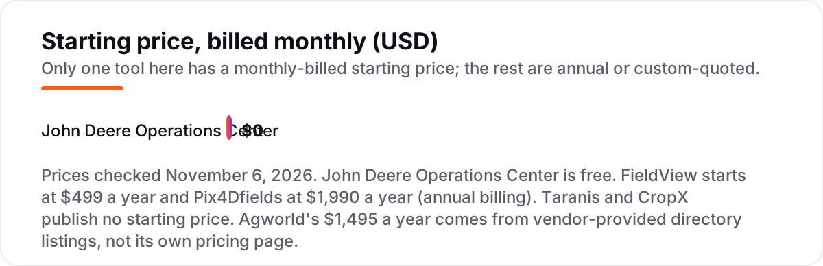
Take a 500-acre corn-and-soybean farm that wants satellite monitoring plus machine data. On list prices, the software costs $0 a year on OneSoil's free Scouting app and $0 on John Deere Operations Center, $499 a year on Climate FieldView Plus, $1,495 a year on Agworld Basic and $1,990 a year on Pix4Dfields. Taranis and CropX publish no starting price, so their cost is a quote: Taranis prices per acre by service plan, and CropX prices per sensor plus an annual subscription.
Over a year, that is $0 at the free end and $1,990 at the dear end for the published prices — but the published price is rarely the whole bill. Pix4Dfields needs a drone, flights and pilot time on top of the $1,990; FieldView needs FieldView Drive hardware on top of the $499; CropX needs a sensor in every field you want measured; and Taranis bundles its drone flights into the quoted service price, so the quote is the bill. Add Agworld Basic at $1,495 to FieldView Plus at $499 and the two together cost $1,994 a year — almost exactly the Pix4Dfields subscription alone — which shows how fast a stack of cheap tools becomes an expensive one.
Three costs sit outside every number above. First, the annual billing: FieldView, Pix4Dfields and Agworld all charge once a year, so the money leaves before the season and there is no monthly option to cancel after harvest. Second, the per-acre and per-sensor math: a quote that looks small per acre or per sensor grows with every acre and every field you add, so price the whole farm, not the first field. Third, the data itself: if the tool cannot export your field boundaries, yield maps and scouting notes, switching later means starting over. For the numbers behind the maps, see our guide to the best big data analytics software.
Know the difference: satellite imagery vs drone imagery vs soil sensors
The confusion in this category is between three data sources that answer three different questions. Satellite imagery shows vegetation zones and trends across whole farms, cheaply and often — it is the scouting tool, and OneSoil is the clearest example. Drone imagery shows individual leaves, so it catches early disease, insect damage and nutrient stress that satellites miss — Taranis and Pix4Dfields work this way. Soil sensors measure moisture, temperature and conductivity in the root zone, which neither camera can see — that is CropX's job.
A second, quieter confusion is between monitoring and record-keeping. Monitoring tools tell you what is happening in the field right now; record-keeping tools like Agworld tell you what was planned, sprayed and spent, and whether it paid. A farm needs both, but they are different purchases: imagery without records cannot prove a treatment worked, and records without imagery cannot say where to look next.
A third distinction worth knowing is the app versus the system. OneSoil and FieldView's Trial plan are apps you can start using today; Taranis is a flown service, CropX is sensors plus software, and Operations Center is an account that only works when the hardware is already in the shed. The app price is never the system price — price the flights, the sensors and the dealer hardware before comparing two tools on their subscription alone.
Quick comparison: tool type by need
| Buyer | Best pick | Why |
|---|---|---|
| Grower starting out, no budget | OneSoil | Free Scouting app with satellite monitoring and a daily AI agronomist |
| Most row-crop farms | Climate FieldView | Connected platform with machine data and scripts, Plus from $499/year |
| Earliest detection on high-value acres | Taranis | Leaf-level AI drone imagery, custom-quoted per acre |
| Irrigated farm watching water costs | CropX | Soil sensors and irrigation scheduling, custom-quoted per sensor |
| Grower who already flies a drone | Pix4Dfields | Fast in-field maps and prescription files, $1,990/year |
| Team working with an agronomist | Agworld | Shared plans, spray records and budgets, Basic from $1,495/year |
| Farm running John Deere machines | John Deere Operations Center | Machine and field data in a free account, with JDLink included |
Mistakes to avoid
- Budgeting on the subscription and forgetting the system. The app price is the small part: drones, sensors, FieldView Drive and dealer hardware are where the money goes. Price the whole system before comparing two subscriptions.
- Buying satellite monitoring and expecting leaf-level answers. Satellite views flag weak zones; they cannot name the disease or the insect. If early detection is the job, the answer is drone imagery or a walk, not a sharper satellite map.
- Paying annually before a one-field trial. FieldView, Pix4Dfields and Agworld all charge once a year. Run one field for a season first — if the flags do not match your own scouting notes, the annual fee is already spent.
- Ignoring the per-acre and per-sensor math. A quote that looks small per acre or per sensor doubles when the farm doubles. Price the whole farm, including every field you would actually monitor, before signing.
- Locking your field data in. If a tool cannot export boundaries, yield maps and scouting notes, leaving later means starting over. Check the export before the trial ends, not after the renewal. For the analytics side of that data, see our guide to the best product analytics tools.
How we chose
We checked each vendor's own pricing page on November 6, 2026 and recorded the starting price exactly as shown, including the annual-billing figure where the page lists one, and we ranked the tools by fit for the most common buyer — a US row-crop grower who wants to catch problems early — not by brand size. Two prices are not vendor-verified: Agworld's $1,495 a year comes from vendor-provided listings on G2 and Capterra, not from Agworld's own pricing page, and Taranis and CropX publish no starting price at all, so they are listed as custom quote. OneSoil's Pro price is also unpublished, so only its free Scouting app is priced here. Ratings are shown only where we opened the G2 page on November 6, 2026: Climate FieldView at 4.5/5 and Agworld at 4.7/5, each from just 3 reviews. No vendor paid for a place in this list, and none of the links here are affiliate links.
What to do next
Start with the free option that matches your farm: OneSoil's Scouting app if you want satellite monitoring today, or Operations Center if you already run Deere machines, then add the paid tool that answers your biggest cost — water, inputs or lost yield. Trial it on one field for a season and compare its flags against your own scouting notes before paying for the whole farm. If the monitoring is sorted but new customers are not finding you, our monthly SEO service handles the visibility side. Once your tools are in place, find out what's holding your rankings back.
Your stack only works if people find you
SerpAstra fixes what keeps your site off page one and makes it easy for AI assistants to recommend.
Get a free audit→Sources we checked (9)
- OneSoil Scouting app listing — appagg.com (checked November 6, 2026)
- Climate FieldView pricing — climate.com/en-ca/pricing.html (checked November 6, 2026)
- Climate FieldView reviews — g2.com/products/climate-fieldview/reviews (checked November 6, 2026)
- Taranis pricing — softwr.com/software/taranis (checked November 6, 2026)
- CropX pricing — softwareworld.co/software/cropx-reviews/ (checked November 6, 2026)
- PIX4Dfields pricing — pix4d.com/pricing/pix4dfields/ (checked November 6, 2026)
- Agworld pricing — agworld.com/au/pricing/ (checked November 6, 2026)
- Agworld reviews — g2.com/products/agworld/reviews (checked November 6, 2026)
- John Deere Operations Center — deere.com (checked November 6, 2026)
Shamim
Founder of SerpAstra
A full-stack SEO and digital marketer who spends most days on Local SEO for dental practices, AI search visibility and lead generation.
Frequently asked questions
What is the best app for crop monitoring?
It depends on the data you need. OneSoil is the best free start for satellite monitoring, Climate FieldView is the best connected platform at $499 a year, and Taranis is the best for leaf-level detection. The right pick follows the biggest cost on your farm: water, inputs or lost yield.
How much do crop monitoring apps cost?
Entry prices run from $0 to $1,990 a year. OneSoil's Scouting app and John Deere Operations Center are free, Climate FieldView Plus starts at $499 a year, Agworld Basic at $1,495 a year and Pix4Dfields at $1,990 a year. Taranis and CropX are custom-quoted, and sensors and drone hardware cost extra.
Do I need a drone or sensors for crop monitoring?
No. OneSoil and John Deere Operations Center work from satellite and machine data without extra hardware, while Taranis flies drones as a service and CropX uses soil sensors. Start with satellite monitoring, then add sensors or drone imagery for the fields where early detection saves real money.
What is NDVI?
NDVI, the normalized difference vegetation index, compares red and near-infrared light reflected by plants to estimate vegetation health. Darker or lower zones on a vegetation map often signal stress from moisture, compaction or nutrients, and those zones need a closer look in person or with drone imagery.
Can crop monitoring apps help with irrigation?
Yes, and CropX is built for it: soil sensors report moisture from the root zone and the platform schedules irrigation only when the soil needs water. Satellite tools help too by flagging dry zones, but they cannot measure soil moisture directly, so sensor data is the reliable basis for watering decisions.
Is there a free crop monitoring app?
Yes. OneSoil's Scouting app is free, with satellite field monitoring, field weather and scouting notes, and John Deere Operations Center is free for Deere equipment owners. Climate FieldView also has a free Trial plan at $0 a year. The paid tiers add imagery history, scripting and prescription maps.
Which crop monitoring app works with John Deere equipment?
John Deere Operations Center is the native choice and it is free, with JDLink streaming machine data at no subscription cost. Climate FieldView also connects to most equipment types including Deere, and Agworld shares data with Deere machines through integrations. Check your display and receiver models before committing.
Free SEO and AI visibility audit
Find out what is holding your rankings back
Send us your site. Within 2 business days you get a written audit, an AI visibility check and a short fix list ranked by impact. Free, with no contract attached.
Request my free audit→Related guides
 Digital Marketing & Ads10 Best Weather Apps without Ads in 2026: Free and Paid Apps RankedCompare the 10 best weather app without ads on price, radar and forecast depth, with every price checked November 5, 2026. Free picks come first.Read guide →
 IT, Security & DevOps10 Best Big Data Analytics Software in 2026, ComparedCompare the 10 best big data analytics software platforms on price, free tiers and AI features, with every price checked on November 6, 2026.Read guide →
 SEO & AI Search10 Best Product Analytics Tools in 2026 (Free and Paid, Compared)10 best product analytics tools compared on price, free plans and fit, from Mixpanel and Amplitude to free GA4. Priced from vendor pages, November 2026.Read guide →