
9 Best Mapping Software for Commercial Real Estate in 2026, Compared
Compare the 9 best mapping software for commercial real estate on price, demographics, foot traffic and free plans, with every price checked November 8, 2026.
 Shamim Mia, Founder, SerpAstraLast verified November 8, 202614 min read
We compare pricing pages, documentation and public reviews. We never accept payment for rankings.

Key takeaways
- Esri ArcGIS Pro is the best fit for most CRE teams, but it is quote-only; SiteSeer is the best purpose-built pick for retail site selection, and Placer.ai is the best source of foot-traffic data.
- The cheapest real start is free: QGIS and Google Earth Pro cost $0, and Mapbox gives 50,000 map loads a month free, while BatchGeo Pro is the only priced tool under $100 a month.
- The single most important buying factor is what the map is for: analysis, site selection, foot traffic or presentation need different tools, and no single product here does all four well.
- Four of the nine tools publish no starting price, so get a written quote before comparing them with the priced tools — a quote-only tool cannot win on price until you know the number.
On this page
Quick comparison
| Tool | Best for | Starting price | Free plan |
|---|---|---|---|
| Esri ArcGIS Pro | CRE teams that need full GIS analysis, 3D modeling and demographic layers in one desktop platform | Custom quote | No (21-day trial) |
| SiteSeer | Retail landlords and brokers who need trade-area scorecards, void analysis and sales forecasts for shopping centers | Custom quote | No (free trial) |
| Placer.ai | Retail and office investors who judge a site by real foot traffic and trade-area visits | Custom quote | Yes (free edition) |
| CARTO | Teams that run spatial analysis in the cloud and publish interactive maps from warehouse data | Custom quote | No (free trial) |
| Mapbox | Developers building branded listing maps, trade-area layers and search into a CRE website or portal | $0 (free tier) | Yes (free tier) |
| Maptitude | Small CRE firms that want desktop demographics and drive-time rings without Esri's price or learning curve | $795/yr | No (free trial) |
| BatchGeo | Brokers who turn a spreadsheet of properties into a shareable Google map in minutes | $99/mo | Yes (free) |
| QGIS | Analysts who want a full desktop GIS at $0 and can add CRE data and plug-ins themselves | Free | Yes (free) |
| Google Earth Pro | Anyone who needs a fast visual check of a site, its surroundings and historical imagery before a deal | Free | Yes (free) |
Make one of these tools?
We re-check this list every quarter. Send a correction, request a review, or ask about a clearly labeled sponsored spot.
Request a listingThe best mapping software for commercial real estate

Esri ArcGIS Pro
Best for: CRE teams that need full GIS analysis, 3D modeling and demographic layers in one desktop platform
Esri ArcGIS Pro is the tool most GIS professionals reach for first, and it earns that place: it handles the whole job — parcel mapping, demographic overlays, drive-time analysis, 3D site modeling and print-ready exhibits — in one desktop platform, with ArcGIS Online sharing the results on the web. You buy it as an annual user-type license, Creator, Professional or Professional Plus, each step up adding a higher Pro license level.
There is no published price: Esri's pricing page describes the user types and sends you to sales, so a CRE team cannot compare it with Maptitude's $795 a year without a quote. The learning curve is real, and network and spatial extensions cost extra. Buy ArcGIS Pro when the analysis is the product; buy Maptitude or QGIS when the map is a means to a deal.
What we like
- The professional GIS standard, with the deepest spatial analysis, 3D modeling and geoprocessing in this list
- ArcGIS Online sharing puts the same maps on the web for clients and colleagues
- Huge demographic, parcel and imagery data catalogs plug straight into the map
- Python automation and ModelBuilder repeat the same analysis across every market
Watch out for
- No published dollar price — every quote runs through Esri sales or a reseller
- The learning curve is steep, and the full feature set needs paid extensions on top
- Per-user annual licenses make a large team expensive before any data is bought

SiteSeer
Best for: Retail landlords and brokers who need trade-area scorecards, void analysis and sales forecasts for shopping centers
SiteSeer was designed by retail analysts, and it shows in the workflow: pick a site, draw the trade area, and the platform scores it against demographics, spending, competition and the voids — the tenant categories the trade area is missing. Void Analysis is the feature landlords use most, because it names the chains that fit a center, and a single report costs $199.99 without a subscription.
The catch is the platform price, which is quoted annually and never published, so a team cannot place SiteSeer against Placer.ai or CARTO without two sales calls. It is also retail-first: the models and data serve shopping centers and restaurants far better than offices or warehouses. Buy SiteSeer when tenant selection decides the deal; buy Placer.ai when foot traffic is the question.
What we like
- Built for site selection: scorecards, analog and machine-learning sales forecasts, and void analysis in one place
- Void Analysis reports can be bought one at a time at $199.99 each without a subscription
- Retail Match scores show which chains fit a trade area, which is what landlords actually need
- Do-it-yourself or done-with-you: the vendor's own analysts can build the models
Watch out for
- No published platform price — the subscription is quoted, so comparison needs a sales call
- Retail-first: office and industrial users get less from the models and data
- The interface looks dated next to newer cloud mapping tools, reviewers say

Placer.ai
Best for: Retail and office investors who judge a site by real foot traffic and trade-area visits
Placer.ai answers the question brokers ask first about a retail site: how many people actually come here, and from where? Its visit data comes from mobile-device panels covering any US property, so you can compare a site with its competitors, draw the trade area from real visitor origins, and check whether a new store would cannibalize your own locations. The free edition gives a limited sample of the same data.
The price is quote-only, and the public record is sobering: city contracts put annual subscriptions at roughly $12,000 to $31,000 a year, which prices out a small brokerage. The free edition is a real test drive but not a working tool. Buy Placer.ai when visit counts decide the investment; buy SiteSeer when the tenant mix matters more.
What we like
- Visit data from mobile-device panels for any US property, competitors included
- Trade areas drawn from where a location's visitors actually come from
- Cannibalization checks show whether a new site steals visits from your own stores
- API and data feeds carry the same data into internal models and dashboards
Watch out for
- No published price — subscriptions are quoted, and public contracts run from about $12,000 a year upward
- The free edition shows only a limited sample of the platform, not the full data
- Foot-traffic data is strongest for retail; office and industrial coverage is thinner

CARTO
Best for: Teams that run spatial analysis in the cloud and publish interactive maps from warehouse data
CARTO is the cloud-native option in this list: instead of downloading data to a desktop, it runs spatial analysis inside the data warehouse — BigQuery, Snowflake, Databricks or Redshift — and its Builder turns the results into interactive maps anyone can open in a browser. Basemaps are free for commercial use up to 1 million requests a month, and the paid plans are usage-based Enterprise contracts.
The trade-off is the audience. CARTO is built for analysts and developers, and a broker who wants a quick property map will find it slower than BatchGeo or Google Earth Pro. There is also no small self-serve tier since the old Individual plan was removed. Buy CARTO when the portfolio data already lives in a warehouse; buy Mapbox when you are building a public listing map.
What we like
- Runs spatial analysis where the data lives, in BigQuery, Snowflake, Databricks or Redshift
- Builder turns warehouse queries into shareable interactive maps without a desktop app
- Basemaps are free for commercial use up to 1 million requests a month
- Strongest ease-of-use scores of the cloud platforms here, at 4.5 out of 5 on G2
Watch out for
- No published platform price — Enterprise plans are quoted on usage, so budgeting needs a sales call
- Built for analysts and developers, not for a broker who wants a map in ten minutes
- The old $299-a-month Individual plan is gone, so there is no small self-serve tier

Mapbox
Best for: Developers building branded listing maps, trade-area layers and search into a CRE website or portal
Mapbox is a mapping platform for developers, not a finished CRE product: it supplies the tiles, the styling and the APIs, and your team builds the listing map, the trade-area layer and the search on top. The free tier covers 50,000 web map loads a month, and beyond that you pay $5 per 1,000 loads, so a small brokerage site can run at $0 for a long time.
The costs to watch are usage and labor. There is no spending cap, so a traffic spike bills without warning, and Mapbox ships no CRE data at all — demographics, parcels and comps must come from elsewhere. Building anything beyond a basic map needs a developer. Buy Mapbox when the website is the product; buy BatchGeo when the map itself is the deliverable.
What we like
- 50,000 web map loads a month free, then $5 per 1,000 — a small listing site can run at $0
- Mapbox Studio gives pixel-level control over the map style, so listings match the brand
- Geocoding, directions and search APIs cover the full stack behind a property portal
- Volume discounts apply automatically as usage grows, with no renegotiation
Watch out for
- Usage-based billing with no spending cap, so a traffic spike can raise the bill without warning
- No CRE data of its own — demographics, parcels and comps must come from other sources
- Building anything beyond a basic map needs a developer, not a broker

Maptitude
Best for: Small CRE firms that want desktop demographics and drive-time rings without Esri's price or learning curve
Maptitude is the value desktop GIS: one $795 first-year price buys the software and a Country Package of US maps and demographic data down to Census Block Group level, with drive-time rings, trade areas and territory mapping built in. It holds the highest G2 score in this list, 4.7 out of 5 across 150 reviews, and reviewers praise its support and ease of use most.
The limits are the desktop model. Sharing a map means exporting a file, not sending a live link, and the license covers one user, so a three-person team pays $2,385 a year. The bundled demographics are US data; other countries are separate packages. Buy Maptitude when one analyst does the mapping; buy CARTO when the whole team needs the maps on the web.
What we like
- Highest G2 score in this list, 4.7 out of 5 across 150 reviews, with support praised most
- US demographic data down to Census Block Group level is bundled in the Country Package
- Drive-time rings, trade areas and territory mapping are built in, not add-ons
- One $795 first-year price covers the software and the data, with no per-map charges
Watch out for
- Desktop-only at the entry price, so sharing maps means exporting files, not a live link
- One user per license — a three-person team buys three licenses
- The demographic data is US-focused, with other countries sold as separate packages

BatchGeo
Best for: Brokers who turn a spreadsheet of properties into a shareable Google map in minutes
BatchGeo is the fastest tool in this list: paste a spreadsheet of addresses and you get a color-coded, shareable Google map in minutes, with no GIS training and no desktop software. Pro costs $99 a month and covers 10 users with up to 100,000 markers per map, plus heat maps, boundary maps, route optimization and KML export. It is also the most-reviewed tool here, at 4.7 out of 5 across 1,047 G2 reviews.
The free plan is the catch: it stops at 250 records per map, so any real portfolio needs the $99 Pro plan. BatchGeo is also a presentation tool, not an analysis tool — there are no demographics, drive-time rings or spatial models, and the base map is Google's. Buy BatchGeo when the map is the deliverable; buy Maptitude when the analysis behind it matters.
What we like
- Paste a spreadsheet and get a color-coded map in minutes, with no GIS training needed
- Most-reviewed tool here: 4.7 out of 5 across 1,047 G2 reviews, with ease of use praised most
- Pro covers 10 users and up to 100,000 markers per map for one flat $99 a month
- Heat maps, boundary maps, route optimization and KML export are included on Pro
Watch out for
- The free plan caps at 250 records per map, so a real portfolio needs Pro at $99 a month
- Built on Google Maps, so the base map style and data are Google's, not yours
- No real GIS analysis — no demographics, drive-time rings or spatial modeling

QGIS
Best for: Analysts who want a full desktop GIS at $0 and can add CRE data and plug-ins themselves
QGIS is a full desktop GIS that costs nothing: it is free and open source, with no paid edition, no user caps and no feature limits, and it reads nearly every GIS format, from shapefiles and GeoJSON to PostGIS. Hundreds of plug-ins add drive-time analysis, 3D views and print layouts, and it runs on Windows, Mac and Linux, so the whole team can share the same project files.
The price of free is self-reliance. There is no support contract and no vendor to call, the interface is functional rather than polished, and no CRE data ships with it — demographics, parcels and comps must be found, bought and loaded yourself. Buy QGIS when the budget is $0 and the analyst is capable; buy Maptitude when bundled data is worth $795 a year.
What we like
- Free and open source forever, with no paid edition and no user or feature caps
- Reads nearly every GIS format, from shapefiles and GeoJSON to PostGIS databases
- Hundreds of plug-ins add drive-time analysis, 3D views, print layouts and more
- Runs on Windows, Mac and Linux, so the whole team can use the same files
Watch out for
- No support contract and no vendor to call — help comes from the community
- No built-in CRE data: demographics, parcels and comps must be found and loaded yourself
- The interface is functional rather than polished, and plug-in quality varies

Google Earth Pro
Best for: Anyone who needs a fast visual check of a site, its surroundings and historical imagery before a deal
Google Earth Pro is the quickest visual check in commercial real estate: open the desktop app, fly to the address, and you see satellite imagery, 3D buildings, Street View and years of historical imagery, with tools to measure parcels, import KML and shapefiles, and print high-resolution images. It is free, with no licence key, and it holds a 4.6 out of 5 G2 rating across 385 reviews.
The catch is the calendar: Google ends new desktop downloads on June 25, 2027, so it is a tool with a known end date, not a platform to build on. It also shows imagery, not analysis — no demographics, parcels or comps. Download it now if you do not have it; pair it with QGIS or Maptitude for the analysis it cannot do.
What we like
- Free, with high-resolution satellite imagery, 3D buildings and Street View built in
- Historical imagery shows how a site and its trade area changed over the years
- Imports KML, shapefiles and GeoJSON, measures areas and distances, and prints high-resolution images
- Rated 4.6 out of 5 on G2 across 385 reviews, the second-highest score here
Watch out for
- Google ends new desktop downloads on June 25, 2027, so it is not a long-term platform
- No demographic, parcel or comp data — it shows imagery, not analysis
- No team sharing or cloud project storage; projects live as KML files on one machine
The best mapping software for commercial real estate does one of four jobs well: deep GIS analysis, site selection, foot-traffic measurement, or fast presentation of a portfolio on a map. We ranked the nine tools below by fit for the most common buyer — a US brokerage or investment team judging sites and presenting them to clients — starting with the professional GIS standard and ending with the free visual tools, and every price was checked on November 8, 2026.
How to choose the best mapping software for commercial real estate
- Name the job before the tool. Analysis needs ArcGIS Pro, QGIS or Maptitude; site selection needs SiteSeer or Placer.ai; a client-facing listing map needs Mapbox or BatchGeo.
- Check what data ships with it. Maptitude bundles US demographics, SiteSeer adds spending and forecasts, and Placer.ai adds visit counts — QGIS, BatchGeo and Google Earth Pro ship none of it.
- Count the users the way the vendor does. Maptitude is per user, BatchGeo Pro covers 10 users flat, and ArcGIS Pro is per annual user-type license — the same three-person team costs very different amounts.
- Ask what the quote-only tools cost in writing. ArcGIS Pro, SiteSeer, Placer.ai and CARTO publish no starting price, so a comparison without their written quote is guesswork.
- Plan for the end date. Google Earth Pro stops new downloads on June 25, 2027, so build nothing long-term on it alone.
Choosing software is one part of running the business; getting found is the other. Our local SEO service covers the visibility side for real estate firms, and before you publish new listing pages, run your titles through the free SERP snippet preview tool — it shows exactly how the title and description will look in Google.
Whatever you shortlist, try it with real portfolio data before you pay. The free plans, free tiers and trials in this list are long enough to map fifty genuine properties — your parcels, your trade areas, your comps — and that test tells you more than any review can. Check three things in the trial: that the map builds without manual fixing, that the data layers you need are actually included, and that the export opens cleanly in the tool your clients already use.
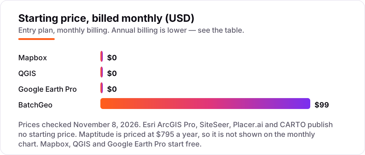
Mapping software pricing: what you will actually pay
Take a three-person CRE team mapping a 50-property portfolio. On list prices, the subscription costs $0 a month on Mapbox within the free tier, QGIS and Google Earth Pro, $99 on BatchGeo Pro, and $795 a year on Maptitude for one user. Three of those numbers need adjusting before they are real: Maptitude is licensed per user, so three analysts cost $2,385 a year; BatchGeo Pro covers 10 users, so the same $99 covers the whole team; and Mapbox stays at $0 only while the listing site stays under 50,000 map loads a month.
Over a year, that is $0 on the three free tools, $1,188 on BatchGeo Pro billed monthly, and $2,385 on Maptitude for three users. The same three people and the same 50 properties cost $0 at the free end and $2,385 at the priced end — a gap that comes entirely from whether the tool bundles data and how it counts users, not from features. The four quote-only tools sit outside this math entirely: ArcGIS Pro, SiteSeer, Placer.ai and CARTO all need a written quote before they can be compared at all.
Three costs sit outside every number above. First, the data: parcel records, demographic feeds and comp data are usually bought separately, and only Maptitude bundles US demographics in its headline price. Second, the build cost: Mapbox and CARTO need developer time to become a CRE tool, which is a salary cost, not a subscription. Third, the per-report charges: SiteSeer sells single Void Analysis reports at $199.99 each, so a team that buys ten reports a year spends about $2,000 without ever subscribing. If the team also needs to underwrite the deals behind the maps, see our guide to the best real estate investment analysis software.
Annual billing cuts the bill on some tools here, but read both figures before paying: Maptitude's $795 is already an annual price with no monthly option, and Mapbox has no annual plan at all — it bills by usage every month. One more cost to check before you commit: a second market is a second data package on Maptitude and a second set of trade-area models on SiteSeer, so price the growth before you commit to the entry plan.
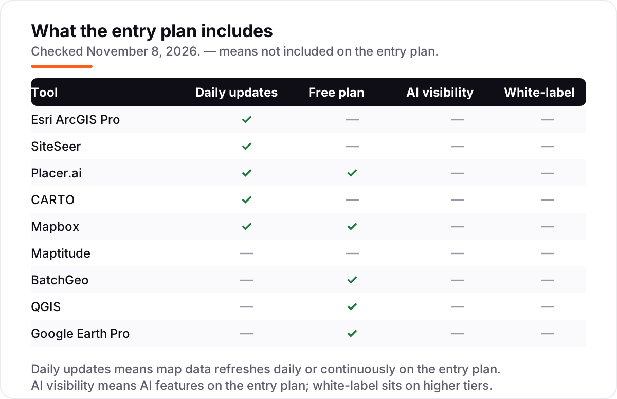
Know the difference: GIS platforms vs site-selection tools
The confusion in this category is between a platform and a purpose-built answer. A GIS platform — ArcGIS Pro, QGIS, Maptitude, CARTO, Mapbox — is a general mapping system that works with any geographic data you load into it. It can do site selection, but you build the model yourself. A site-selection tool — SiteSeer and Placer.ai — is built for one job: judging whether a specific site will work, with trade areas, forecasts and foot traffic already inside.
There is a second, quieter confusion: a map is not an analysis. Google Earth Pro and BatchGeo make beautiful maps, but they do not answer whether a site will perform — they show where things are, not what they mean. ArcGIS Pro, Maptitude and QGIS add the analysis layer, and SiteSeer and Placer.ai add the answer layer on top of that. Buying a presentation tool when you need an answer is the most common mistake in this category.
A third distinction worth knowing is data versus software. The software is often the cheap part: a $0 QGIS install still needs demographic, parcel and comp data, and that data is usually bought separately. Maptitude is the exception in this list, because its $795 first-year price bundles US demographics. When you compare a free tool with a $795 tool, compare the total — software plus the data feeds each one needs — or the free tool will look cheaper than it is.
Quick comparison: tool type by need
| Buyer | Best pick | Why |
|---|---|---|
| Most CRE teams | Esri ArcGIS Pro | The professional GIS standard, custom quote, 21-day trial |
| Retail site selection | SiteSeer | Scorecards and void analysis, custom quote, reports from $199.99 |
| Foot traffic and trade areas | Placer.ai | Real visit data for any US property, custom quote, free edition |
| Cloud analysis from warehouse data | CARTO | Spatial analysis in BigQuery or Snowflake, custom quote |
| Branded listing maps on a website | Mapbox | Free tier of 50,000 map loads a month, then $5 per 1,000 |
| Desktop demographics on a budget | Maptitude | $795 a year for one user, highest G2 score here at 4.7/5 |
| Fast spreadsheet-to-map | BatchGeo | Pro is $99 a month for 10 users, free plan to 250 records |
| Full GIS at $0 | QGIS | Free and open source, no paid edition, no user caps |
| Quick visual site check | Google Earth Pro | Free, but new downloads end June 25, 2027 |
Mistakes to avoid
- Buying a presentation tool when you need an answer. Google Earth Pro and BatchGeo show where things are; they do not forecast sales or score a trade area. If the decision is the point, shortlist SiteSeer or Placer.ai first.
- Comparing a quote-only tool with a priced one. ArcGIS Pro, SiteSeer, Placer.ai and CARTO publish no starting price, so any ranking that puts them against $99 or $795 without a written quote is guesswork.
- Budgeting on the software and forgetting the data. Demographics, parcels and comps are usually bought separately — only Maptitude bundles US demographics in its headline price, so add the data feeds to every other tool's total.
- Building on Google Earth Pro for the long term. New desktop downloads end on June 25, 2027. Use it for checks today, and keep the real work in a tool with a future.
- Paying annually without checking the math. Not every annual figure is a discount — read the monthly and annual numbers side by side before committing to a year, and confirm whether data packages renew at the same price.
How we chose
We checked each vendor's own pricing page on November 8, 2026 and recorded the starting price exactly as shown. Esri's ArcGIS Pro pricing page publishes no dollar price — ArcGIS Pro is sold through annual user-type licenses via sales — so it is listed as custom quote, as are SiteSeer, Placer.ai and CARTO, whose pricing pages also carry no starting price. BatchGeo's pricing page returned a bot block to our automated check, so its $99-a-month Pro price is corroborated by G2's vendor-provided pricing and BatchGeo's own blog. Maptitude's $795 is an annual first-year price with no monthly figure, so it is not shown on the monthly chart and no monthly equivalent is asserted. Capterra lists a $1,495-a-year starting price for SiteSeer, but that figure is third-party-sourced and the vendor publishes no platform price, so SiteSeer stays custom quote here. Ratings come only from G2 and Capterra pages with the score and review count shown. We ranked the tools by fit for the most common buyer — a US brokerage or investment team judging sites and presenting them to clients — not by brand size. No vendor paid for a place in this list, and none of the links here are affiliate links.
What to do next
Start with the free tools: open the site in Google Earth Pro for the visual check, load the parcels into QGIS for the analysis, and map the portfolio in BatchGeo for the client presentation. That costs $0 and tells you whether the workflow fits before any money moves. Then get written quotes from the quote-only tools on your shortlist — ArcGIS Pro, SiteSeer, Placer.ai and CARTO — and compare them with the priced totals, data feeds included. If the software is sorted but new clients are not finding you, our local SEO service handles the visibility side — or compare providers in our guide to commercial real estate companies. Once your tools are in place, find out what's holding your rankings back.
Your stack only works if people find you
SerpAstra fixes what keeps your site off page one and makes it easy for AI assistants to recommend.
Get a free audit→Sources we checked (18)
- Esri ArcGIS Pro pricing — esri.com/en-us/arcgis/products/arcgis-pro/buy (checked November 8, 2026)
- SiteSeer Void Analysis pricing — blog.siteseer.com (checked November 8, 2026)
- Placer.ai pricing — placer.ai/pricing (checked November 8, 2026)
- CARTO pricing — carto.com/pricing (checked November 8, 2026)
- Mapbox pricing — mapbox.com/pricing (checked November 8, 2026)
- Maptitude pricing — caliper.com/maptitude (checked November 8, 2026)
- BatchGeo pricing — batchgeo.com/pricing (checked November 8, 2026)
- QGIS download — qgis.org/download (checked November 8, 2026)
- Google Earth Pro versions — google.com/earth/about/versions (checked November 8, 2026)
- Esri ArcGIS Pro reviews — G2, 4.3/5, 190 reviews (checked November 8, 2026)
- SiteSeer reviews — Capterra, 4.6/5, 10 ratings (checked November 8, 2026)
- Placer.ai reviews — G2, 4.3/5, 12 reviews (checked November 8, 2026)
- CARTO reviews — G2, 4.5/5, 78 reviews (checked November 8, 2026)
- Mapbox reviews — G2, 4.3/5, 41 reviews (checked November 8, 2026)
- Maptitude reviews — G2, 4.7/5, 150 reviews (checked November 8, 2026)
- BatchGeo reviews — G2, 4.7/5, 1,047 reviews (checked November 8, 2026)
- QGIS reviews — G2, 4.5/5, 154 reviews (checked November 8, 2026)
- Google Earth Pro reviews — G2, 4.6/5, 385 reviews (checked November 8, 2026)
Shamim
Founder of SerpAstra
A full-stack SEO and digital marketer who spends most days on Local SEO for dental practices, AI search visibility and lead generation.
Frequently asked questions
What is the best mapping software for commercial real estate?
Esri ArcGIS Pro is the best fit for most CRE teams: the deepest GIS analysis, 3D modeling and demographic layers, though it is quote-only. SiteSeer is the best purpose-built pick for retail site selection, and Placer.ai is the best source of foot-traffic data. QGIS is the best free option.
How much does mapping software for commercial real estate cost?
Entry prices run from $0 to custom quote. QGIS, Google Earth Pro and Mapbox's free tier cost nothing to start, BatchGeo Pro is $99 a month, and Maptitude is $795 a year for one user. ArcGIS Pro, SiteSeer, Placer.ai and CARTO are all quote-only, so budget for a sales call.
Is there really free mapping software for commercial real estate?
Yes, with limits. QGIS is a full open-source GIS at $0, Google Earth Pro is free for visual checks until downloads end in June 2027, and Mapbox gives 50,000 map loads a month free. None of the three ships with CRE data, so demographics, parcels and comps must come from elsewhere.
What is the difference between GIS software and site-selection software?
GIS software, such as ArcGIS Pro, QGIS and Maptitude, is a general mapping and analysis platform that works with any geographic data. Site-selection software, such as SiteSeer and Placer.ai, is built for one job: judging whether a specific site will work, with trade areas, forecasts and foot traffic built in.
Do I need demographics or foot traffic data to map a commercial site?
For a serious underwriting decision, yes. A map of parcels alone does not tell you who lives nearby or who visits. Maptitude bundles US demographics, SiteSeer adds spending and forecasts, and Placer.ai adds real visit counts. For a simple portfolio map, BatchGeo or Google Earth Pro is enough.
Can I switch mapping software later?
Yes, and it is easier than switching most business software, because the data formats are open. Export parcels, trade areas and property lists as shapefiles, GeoJSON or KML from the old tool, then import them into the new one and re-check the projections. The work that does not transfer is the analysis models.
Does mapping software include parcel or ownership data?
Usually not. None of the nine tools here ships with parcel ownership records as standard. ArcGIS Pro and CARTO connect to parcel data services, Maptitude bundles demographics but not ownership, and QGIS, BatchGeo and Google Earth Pro need you to bring your own parcel files.
Free SEO and AI visibility audit
Find out what is holding your rankings back
Send us your site. Within 2 business days you get a written audit, an AI visibility check and a short fix list ranked by impact. Free, with no contract attached.
Request my free audit→Related guides
 Local Business & Vertical Software12 Best Real Estate Investment Analysis Software in 2026, ComparedCompare the 12 best real estate investment analysis software tools on price, free plans, calculators and data, with every price checked November 8, 2026.Read guide →
 Local Business & Vertical Software9 Best Commercial Real Estate Companies in 2026Compare the 9 best commercial real estate companies on tenant-rep volume, coverage and conflicts, with fees quoted per deal and facts checked November 7, 2026.Read guide →
 Local Business & Vertical Software9 Best Real Estate Development Software in 2026, ComparedCompare the 9 best real estate development software tools on price, feasibility, budgets and draws, with every price checked November 8, 2026.Read guide →