7 Best Digital Wayfinding Software in 2026, Compared
Compare the 7 best digital wayfinding software options for campuses, hospitals and venues, with real prices and quote-only costs checked November 10, 2026.
 Shamim Mia, Founder, SerpAstraLast verified November 10, 202613 min read
We compare pricing pages, documentation and public reviews. We never accept payment for rankings.
Key takeaways
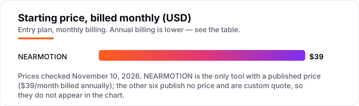
- NEARMOTION is the only tool here with a published price, at $39/month billed annually; MazeMap, MapsPeople and 22Miles lead the shortlist, and the other six tools are custom quote.
- The single most important buying factor is the pricing unit: per building, per floor, per screen or per Wi-Fi access point. The unit, not the headline, decides what a venue actually pays.
- GoodMaps is the accessibility pick, with WCAG 2.2 AA design and step-free routing, while Concept3D is the best-reviewed campus tool at 4.5 out of 5 on G2 from 131 reviews.
- Budget for the whole project, not just the licence: map creation, kiosk hardware and positioning beacons are usually quoted separately.
On this page
Quick comparison
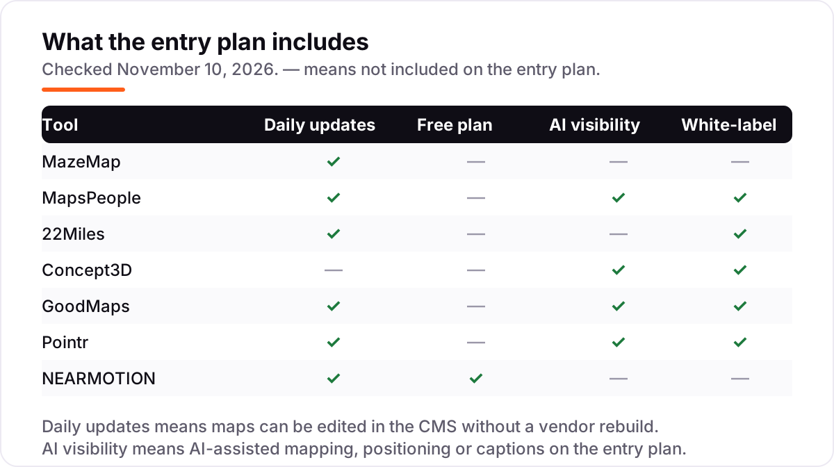
| Tool | Best for | Starting price | Free plan |
|---|---|---|---|
| MazeMap | Universities, hospitals and corporate campuses that need indoor wayfinding over existing Wi-Fi, with room booking built in | Custom quote | No (demo only) |
| MapsPeople | Large enterprises running offices, airports, hospitals or campuses across many buildings and systems | Custom quote | No (demo only) |
| 22Miles | Venues that want touch kiosks plus mobile wayfinding on one CMS, from airports to hospitals | Custom quote | No (demo only) |
| Concept3D | Universities and large campuses that want polished 3D maps, virtual tours and event maps in one place | Custom quote | No (demo only) |
| GoodMaps | Airports, transit hubs, stadiums and museums that need accessible wayfinding for blind and low-vision visitors | Custom quote | No (visitor app free) |
| Pointr | Airports, hospitals, workplaces and retailers that need live blue-dot positioning inside their own app | Custom quote | No (demo only) |
| NEARMOTION | Small venues and single buildings that want a published price and a map live without a sales call | $39/mo | Yes (free) |
Make one of these tools?
We re-check this list every quarter. Send a correction, request a review, or ask about a clearly labeled sponsored spot.
Request a listingThe best digital wayfinding software

MazeMap
Best for: Universities, hospitals and corporate campuses that need indoor wayfinding over existing Wi-Fi, with room booking built in
MazeMap is the best fit for most large venues because it turns the Wi-Fi a building has into indoor positioning. No beacon hardware to buy, install or maintain, and routes run from the car park to the room on one map. Universities, hospitals and corporate campuses use it for searchable maps, room booking and live space data, and the JavaScript API puts the same map inside an existing app, intranet or kiosk.
The trade-off is that pricing is entirely quoted. MazeMap licenses per Wi-Fi access point, and Cisco's price list sets a 50-access-point minimum, so a small building pays for scale it may not need. Positioning also depends on managed Wi-Fi, so a venue without it faces extra setup. Buy MazeMap when the venue is large, runs managed Wi-Fi, and wants one map for wayfinding, booking and space analytics.
What we like
- Indoor positioning runs over the building's existing Wi-Fi (Cisco Spaces, Juniper Mist, HPE Aruba), so no beacons to install
- Step-free and audible turn-by-turn routing, with MazeMap 2.8.1 partially conformant with WCAG 2.2 Level AA
- JavaScript API and SDKs let teams embed maps in their own app, intranet or kiosk
- Maps sync with facility management systems, and the vendor says 5-10% of layouts change yearly
Watch out for
- No published price: licensing is quoted per Wi-Fi access point, with a 50-AP minimum on Cisco's price list
- Positioning depends on the venue's Wi-Fi infrastructure, so sites without managed Wi-Fi need more setup
- Quote-only sales process, so budgeting needs a vendor conversation before any number exists

MapsPeople
Best for: Large enterprises running offices, airports, hospitals or campuses across many buildings and systems
MapsPeople suits the largest deployments because MapsIndoors is built as shared map infrastructure, not a single-venue app. One map feeds the website, the staff app, the kiosk and the booking system, and routes run from outside the building to the desk without switching apps. The vendor claims 99.99% uptime and maps built on more than 3.7 billion square feet, and Map Update Automation uses AI to keep maps current as layouts change.
The cost is the enterprise model. MapsPeople is partner-first, so implementation runs through an integration partner and takes time — G2 reports about two months to go live — and there is no published price, free plan or trial. Delivery is mainly SDKs and APIs, so a team needs developer effort to start. Choose MapsPeople when the estate is large, multi-building and already running workplace or smart-building systems.
What we like
- Built on Google Maps or Mapbox, so routes run from outdoors to indoors without switching apps
- Map Update Automation uses AI to detect layout changes and update maps without manual rework
- Native SDKs for web, iOS, Android, Flutter and React Native, plus 50+ technology partners
- Vendor claims 99.99% uptime and maps built on 3.7 billion-plus square feet
Watch out for
- Enterprise-only and partner-first: implementation runs through partners and takes time (G2 reports about 2 months to implement)
- No published price, free plan or trial, so every deployment starts with a sales conversation
- Delivered mainly as SDKs and APIs, so teams need developer effort to get started

22Miles
Best for: Venues that want touch kiosks plus mobile wayfinding on one CMS, from airports to hospitals
22Miles is the pick when the venue runs on screens. One CMS, Publisher Pro, drives touch kiosks, video walls, mobile and web wayfinding from the same 2D or 3D maps, and routes can be edited in real time when construction closes a corridor. Pricing is based on buildings and floors rather than square footage, with unlimited CMS seats, and G2 reviewers give it 5.0 out of 5, praising responsive support and reliability.
The catch is that everything is quoted, so there is no number to budget against until sales responds, and the kiosk hardware sits on top of the software licence. G2 reviewers also warn the system can feel complex for new users and does not work on macOS. Pick 22Miles when the wayfinding strategy is screen-led and the venue wants kiosks and phones to show the same routes.
What we like
- One CMS runs kiosks, video walls, mobile and web wayfinding with 2D or 3D maps
- Pricing is based on buildings and floors, not square footage, with unlimited CMS seats
- Routes can be edited in real time when construction or a room change closes a path
- Rated 5.0 out of 5 on G2, with reviewers praising responsive support and reliability
Watch out for
- No published price: the vendor quotes per project, so budgeting needs a sales conversation
- Kiosk hardware is an added cost on top of the software licence
- G2 reviewers note the system can be complex for new users and does not work on macOS

Concept3D
Best for: Universities and large campuses that want polished 3D maps, virtual tours and event maps in one place
Concept3D is the campus standard because it sells the visit, not just the route. Interactive 3D maps sit beside virtual tours, event maps and room-level directions, and admins can edit maps without coding once the platform is live. It is the most-reviewed tool in this list at 4.5 out of 5 on G2 from 131 reviews, and reviewers repeatedly praise the support team for fast, knowledgeable help.
The weaknesses are cost transparency and update control. There is no published price, and G2 reviewers say updating the base map render can be pricey, with interior plans and 3D renders editable only by Concept3D itself. Average implementation runs about four months, according to G2. Choose Concept3D when the audience is prospective students and visitors and the map is part of the campus story.
What we like
- Highest-reviewed campus tool here at 4.5 out of 5 on G2, from 131 reviews
- Interactive 3D maps with virtual tours, event maps and room-level directions in one platform
- Admins can edit maps without coding once the platform is live
- Strong support record: G2 reviewers repeatedly praise responsive, helpful support
Watch out for
- No published price, and G2 reviewers say map-render updates can be costly
- Base map renders and interior plans cannot be edited without Concept3D's involvement
- Average implementation runs about 4 months, according to G2, so plan a long rollout

GoodMaps
Best for: Airports, transit hubs, stadiums and museums that need accessible wayfinding for blind and low-vision visitors
GoodMaps is the pick when accessibility is the requirement, not an afterthought. It was built for blind and low-vision navigation, with WCAG 2.2 AA design, audio, haptic and AR guidance, step-free routing and support for more than 25 languages. Positioning uses the phone camera and LiDAR, so it reaches foot-level accuracy with no beacons, and one platform covers web maps, kiosks, an SDK for the venue's own app and a free visitor app.
The limit is coverage: GoodMaps only works where a venue has deployed it, so a visitor's experience is building-by-building, and the venue licence is custom-quoted with no published price. Camera positioning also needs the visitor to hold the phone up to scan. Pick GoodMaps when the venue must serve visitors with disabilities properly, from airports and transit hubs to museums and hospitals.
What we like
- Accessibility-first: WCAG 2.2 AA design with audio, haptic and AR guidance and step-free routing
- Camera-based positioning reaches foot-level accuracy with no beacons or extra hardware
- One platform covers web maps, kiosks, an SDK for the venue's own app, and a ready-made visitor app
- Supports more than 25 languages, and the visitor app is free to download
Watch out for
- No published price: venues buy a licence, so costs come from a sales conversation
- Only works where a venue has deployed it, so coverage is building-by-building
- Camera positioning needs the visitor to hold the phone up, which not every visitor will do

Pointr
Best for: Airports, hospitals, workplaces and retailers that need live blue-dot positioning inside their own app
Pointr is the pick when the venue needs to know exactly where people are, not just show them a map. Its MapScale tool uses AI to build detailed maps from CAD files in minutes, and Deep Location positioning is accurate to under 1-3 metres, works offline on the device and runs on beacons, Wi-Fi, sensors or smart lighting. The map CMS updates every map in real time, and geofencing is built in for location-based messages.
The trade-off is the enterprise sales path. Pointr publishes its two packages, Maps and Maps & Location, but no prices, so every deployment is quoted, and the positioning hardware is a separate cost. There is no free plan or trial, so evaluation runs through a vendor-led demo. Choose Pointr when the venue's own app needs live blue-dot positioning at scale.
What we like
- MapScale uses AI to build detailed maps from CAD files in minutes, not weeks
- Deep Location positioning is accurate to under 1-3 metres and works offline on the device
- Hardware-agnostic: works with beacons, Wi-Fi access points, sensors or smart lighting
- Real-time map CMS updates every map instantly, with geofencing built in
Watch out for
- No published prices: the Maps and Maps & Location packages are quoted by sales
- Positioning hardware (beacons or sensors) is a separate cost on top of the software
- No free plan or trial, so evaluation runs through a vendor-led demo

NEARMOTION
Best for: Small venues and single buildings that want a published price and a map live without a sales call
NEARMOTION is the only tool here a small venue can buy without talking to sales. Launch costs $39 a month billed annually, or $468 a year, for one building with up to five floors, and a free Explore plan covers one building and one floor with no credit card required. Professional at $159 a month billed annually covers three buildings, and annual billing saves 20%.
The limit is live positioning: the blue dot is Enterprise-only, so Launch and Professional give maps and step-by-step routes without showing the visitor's live location. Launch covers a single building, so a multi-site venue must step up. NEARMOTION is a newer, smaller vendor with no public G2 or Capterra review base. Pick it when the venue is small, the budget is fixed and a published price matters more than live positioning.
What we like
- Only published price in this list: Launch is $39/month billed annually, with a free Explore plan
- Start free with one project, one building and one floor, with no credit card required
- Professional at $159/month billed annually covers 3 buildings with 5 floors each
- Annual billing saves 20% against monthly billing on every paid plan
Watch out for
- Live blue-dot positioning is Enterprise-only, so Launch and Professional give maps and routes without live location
- Launch covers a single building, so multi-site venues need Professional or Enterprise
- A newer, smaller vendor with no public G2 or Capterra review base to check against
The best digital wayfinding software guides visitors from the front door to the right room without a staff member in sight, and the seven tools below are ranked by fit for the most common buyer: a venue with one or more complex buildings, from a university campus to a hospital. Six of the seven are custom quote, so this list weighs the product as much as the price, and the only published price belongs to NEARMOTION at $39 a month. Every price was checked on the vendor's own site on November 10, 2026.
How to choose the best digital wayfinding software
- Price it by the vendor's unit, not the headline. MazeMap licenses per Wi-Fi access point, 22Miles by buildings and floors, NEARMOTION by building, and kiosk tools per screen. Ask every vendor for the price of your actual building count, floor count and screen count.
- Decide whether you need live positioning. A map with routes is enough for many venues; a blue dot that follows the visitor needs beacons, Wi-Fi or camera positioning, and costs more. NEARMOTION only offers the blue dot on Enterprise.
- Check who updates the map. Layouts change every year, so ask whether your team can edit routes in a CMS or whether every change is a paid vendor job. Concept3D's base renders need the vendor; MapsPeople automates updates with AI.
- Test the accessible route, not just the main route. Step-free routing, audio guidance and screen-reader support decide whether the tool serves every visitor. GoodMaps leads here, and MazeMap is partially conformant with WCAG 2.2 Level AA.
- Try the visitor journey on a phone. Open the map, find a room, and follow the route as a first-time visitor would. If it needs an app download, a login or a kiosk, count that friction before you buy.
Wayfinding only works if visitors can find the map in the first place, so the venue's website has to rank and the map has to load fast. Our guide to digital signage companies covers the screen side of the same job, and before you publish new venue pages, run them through the free title tag checker to see how they will appear in search. For the visibility side, our local SEO service handles the map-pack and AI-answer work that brings visitors to the door.
Digital wayfinding software pricing: what you will actually pay
Take a single building with five floors and one entrance kiosk. On NEARMOTION, the subscription is $39 a month billed annually, or $468 a year, on Launch, and the free Explore plan covers the same building at $0 while you test it. A three-building site on Professional costs $159 a month billed annually, or $1,908 a year. Those are the only vendor-published numbers in this list: the other six tools are custom quote, so their subscription cost is whatever sales agrees for your buildings, floors and screens.
For a sense of what a quoted kiosk project costs, reseller Displays2Go publishes a 22Miles WayTouch price list: a $4,900 one-time setup fee, a $295-a-year Content Manager Lite subscription and a $995-a-year licence per screen, or $6,190 in the first year for one screen. That is a reseller list, not 22Miles' own pricing, and the vendor itself quotes per project. A three-screen venue on that same reseller list would pay $4,900 plus $295 plus three screen licences at $995, or $8,180 in the first year, before the kiosk hardware itself.
Three costs sit outside every subscription above. First, map creation: a venue with complex floor plans pays for the first map build, whether that is a one-time project fee or part of the quote. Second, hardware: kiosk screens, and beacons or sensors where live positioning is wanted, are bought separately. Third, map updates: some vendors charge per render or per change, so ask what a layout change costs before signing. See our guide to mapping software for commercial real estate for the property-side comparison.
Know the difference: a wayfinding engine, a map, and a screen
The confusion in this category is between three things that look alike on a sales deck. A map shows the building. A screen shows the map. Wayfinding software calculates the route and, where positioning is included, follows the visitor along it. A floor plan on a television is not wayfinding, and neither is a static map on a website: both show, neither guides. The tools in this list all calculate routes; the difference between them is whether they also know where the visitor is.
There is a second confusion, between indoor maps and outdoor navigation. Google Maps and Apple Maps handle the journey to the front door, then stop. Indoor wayfinding picks up where GPS leaves off, across floors, corridors and departments the outdoor apps cannot see. That is why the strongest tools here — MazeMap, MapsPeople and GoodMaps — all describe the handover from outdoor to indoor as one continuous route, and why a venue that only needs the outdoor part should not buy indoor software at all.
A third distinction is the delivery model. Some tools are platforms your team embeds in its own app or website, like MazeMap, MapsPeople and Pointr. Others are ready-made visitor experiences, like the GoodMaps app or a 22Miles kiosk. Neither is better in itself; the question is whether the venue has an app and a team to maintain it, or wants a finished product visitors can use on arrival.
Quick comparison: tool type by need
| Buyer | Best pick | Why |
|---|---|---|
| University or hospital campus | MazeMap | Wi-Fi positioning with no beacons, plus room booking, custom quote |
| Large multi-building enterprise | MapsPeople | One map foundation across buildings, apps and systems, custom quote |
| Venue led by kiosks and screens | 22Miles | One CMS for kiosks, mobile and web, 5.0 out of 5 on G2, custom quote |
| Campus that sells the visit | Concept3D | 3D maps, tours and event maps, 4.5 out of 5 on G2, custom quote |
| Accessibility-first venue | GoodMaps | WCAG 2.2 AA design with audio, haptic and step-free routes, custom quote |
| Own app needing live positioning | Pointr | AI-built maps and blue-dot positioning accurate to under 1-3 metres, custom quote |
| Small venue with a fixed budget | NEARMOTION | Only published price here, $39 a month billed annually, free plan included |
Mistakes to avoid
- Budgeting on a headline price that does not exist. Six of these seven tools are custom quote, so any roundup that prints a monthly price for them is guessing. Get the quote for your buildings, floors and screens before comparing.
- Forgetting the map build. The first map is a project, not a feature: floor plans have to be digitised, routes drawn and points of interest placed. Ask whether that work is in the quote or billed separately.
- Buying live positioning you do not need. Beacons, sensors and the licences that use them add cost and maintenance. If visitors only need a route from the entrance, a map without a blue dot is cheaper and simpler.
- Assuming the venue's own app is enough. A map buried three taps deep in an app visitors do not have helps nobody. Check the kiosk, web and QR-code routes a first-time visitor actually uses.
- Ignoring the update cost. Layouts change every year, and some vendors charge per render or per change. Ask what a moved department or a new wing costs before you sign, not after.
How we chose
We checked each vendor's own site on November 10, 2026 and recorded the starting price exactly as shown. Six of the seven tools publish no price, so they are listed as custom quote rather than given an estimated figure, and we ranked the tools by fit for the most common buyer — a venue with complex buildings — not by brand size. The one exception to vendor pricing is the 22Miles worked example, which uses a price list published by reseller Displays2Go, not by 22Miles, and is labelled as such. Ratings are shown only where a fresh G2 page gave a clear score and review count on November 10, 2026: 22Miles and Concept3D. MapsPeople carries no rating here because its G2 reviews page copy was five days old and its pricing page showed a score without a review count; MazeMap, GoodMaps, Pointr and NEARMOTION have no G2 or Capterra listing for the wayfinding product, and we would rather show no rating than a stale or estimated one. No vendor paid for a place in this list, and none of the links here are affiliate links.
What to do next
Start with the two cheapest paths to a live map: NEARMOTION's free Explore plan, which puts one building online without a sales call, and a demo of the quoted tool that fits your venue best. Walk the route yourself, as a first-time visitor, from the entrance to the hardest room to find, and check the accessible route too. If the map is ready but visitors are not finding the venue, our local SEO service handles the visibility side — or compare the screen-led options in our guide to digital signage companies. Once your tools are in place, find out what's holding your rankings back.
Your stack only works if people find you
SerpAstra fixes what keeps your site off page one and makes it easy for AI assistants to recommend.
Get a free audit→Sources we checked (11)
- MazeMap Cisco price list — mazemap.com/cisco (checked November 10, 2026)
- MazeMap accessibility — mazemap.com/accessibility (checked November 10, 2026)
- MapsPeople — mapspeople.com (checked November 10, 2026)
- MapsPeople on G2 — g2.com/products/mapspeople/reviews (checked November 10, 2026)
- 22Miles — 22miles.com (checked November 10, 2026)
- 22Miles WayTouch pricing, Displays2Go — displays2go.com (checked November 10, 2026)
- 22Miles on G2 — g2.com/products/22miles/reviews (checked November 10, 2026)
- Concept3D on G2 — g2.com/products/concept3d/reviews (checked November 10, 2026)
- GoodMaps platform — goodmaps.com/platform (checked November 10, 2026)
- Pointr — pointr.tech (checked November 10, 2026)
- NEARMOTION pricing — nearmotion.com/pricing (checked November 10, 2026)
Shamim
Founder of SerpAstra
A full-stack SEO and digital marketer who spends most days on Local SEO for dental practices, AI search visibility and lead generation.
Frequently asked questions
What is the best digital wayfinding software?
MazeMap is the best fit for most large venues: Wi-Fi-based positioning with no beacons, room booking and space analytics in one platform. MapsPeople suits the largest multi-building estates, 22Miles leads for kiosk-led venues, and Concept3D is the best-reviewed campus tool at 4.5 out of 5 on G2. Small venues should start with NEARMOTION, the only tool here with a published price.
How much does digital wayfinding software cost?
Only NEARMOTION publishes a price: $39 a month billed annually for one building, with a free plan for testing. The other six tools are custom quote, priced by buildings, floors, screens or Wi-Fi access points. As a guide, reseller Displays2Go lists a one-screen 22Miles project at $6,190 in the first year, before kiosk hardware.
Is there a free digital wayfinding software?
NEARMOTION has a genuinely free Explore plan for one project, one building and one floor, with no credit card required. The GoodMaps visitor app is also free, but the venue still buys a licence. No other tool here offers a free plan; MazeMap, MapsPeople, Concept3D and Pointr offer demos, and 22Miles offers a demo too.
What is the difference between indoor mapping and wayfinding?
An indoor map shows the building; wayfinding calculates the route through it. A static floor plan on a website is a map, not wayfinding. True wayfinding software gives turn-by-turn directions from one point to another, and the stronger tools add live positioning, so visitors can see themselves moving along the route.
Do I need beacons or extra hardware for indoor wayfinding?
Not always. MazeMap positions visitors over existing Wi-Fi, and GoodMaps uses the phone camera, so neither needs beacons. Pointr works with beacons, Wi-Fi, sensors or smart lighting, and 22Miles kiosks are screens you buy separately. Ask each vendor what positioning your building needs before budgeting for hardware.
How long does it take to launch digital wayfinding?
It depends on the tool. NEARMOTION's free plan can put one building online the same day, with no sales call. G2 reports about two months to implement MapsPeople and about four months for Concept3D, which includes building the 3D map renders. Budget extra time when the venue needs new floor plans drawn or hardware installed.
Which wayfinding software is best for accessibility?
GoodMaps is the accessibility-first pick: it was built for blind and low-vision navigation, with WCAG 2.2 AA design, audio and haptic guidance, AR directions and step-free routing in more than 25 languages. MazeMap also offers step-free and audible routing and is partially conformant with WCAG 2.2 Level AA.
Free SEO and AI visibility audit
Find out what is holding your rankings back
Send us your site. Within 2 business days you get a written audit, an AI visibility check and a short fix list ranked by impact. Free, with no contract attached.
Request my free audit→Related guides
 Companies & Services11 Best Digital Signage Companies in 2026Compare the 11 best digital signage companies on per-screen price, free plans and hardware, with every price checked November 4, 2026, before you buy.Read guide →
 Local Business & Vertical Software9 Best Mapping Software for Commercial Real Estate in 2026, ComparedCompare the 9 best mapping software for commercial real estate on price, demographics, foot traffic and free plans, with every price checked November 8, 2026.Read guide →
 Digital Marketing & Ads9 Best Event Marketing Platforms for 2026 (Pros, Cons and Pricing)9 best event marketing platforms compared with real prices, G2 ratings and free plans. Find the right fit for conferences, webinars and ticketed events.Read guide →