
Best Geospatial Software for 2026: 10 Options Compared by Use Case
Best geospatial software compared by use case: 10 options with real 2026 prices, free plans and ratings, from free QGIS to enterprise ArcGIS Pro.
 Shamim Mia, Founder, SerpAstraLast verified November 10, 202611 min read
We compare pricing pages, documentation and public reviews. We never accept payment for rankings.
Key takeaways
- QGIS is the best free desktop GIS, ArcGIS Pro is the enterprise standard, and Global Mapper is the best paid desktop pick at $599 a year.
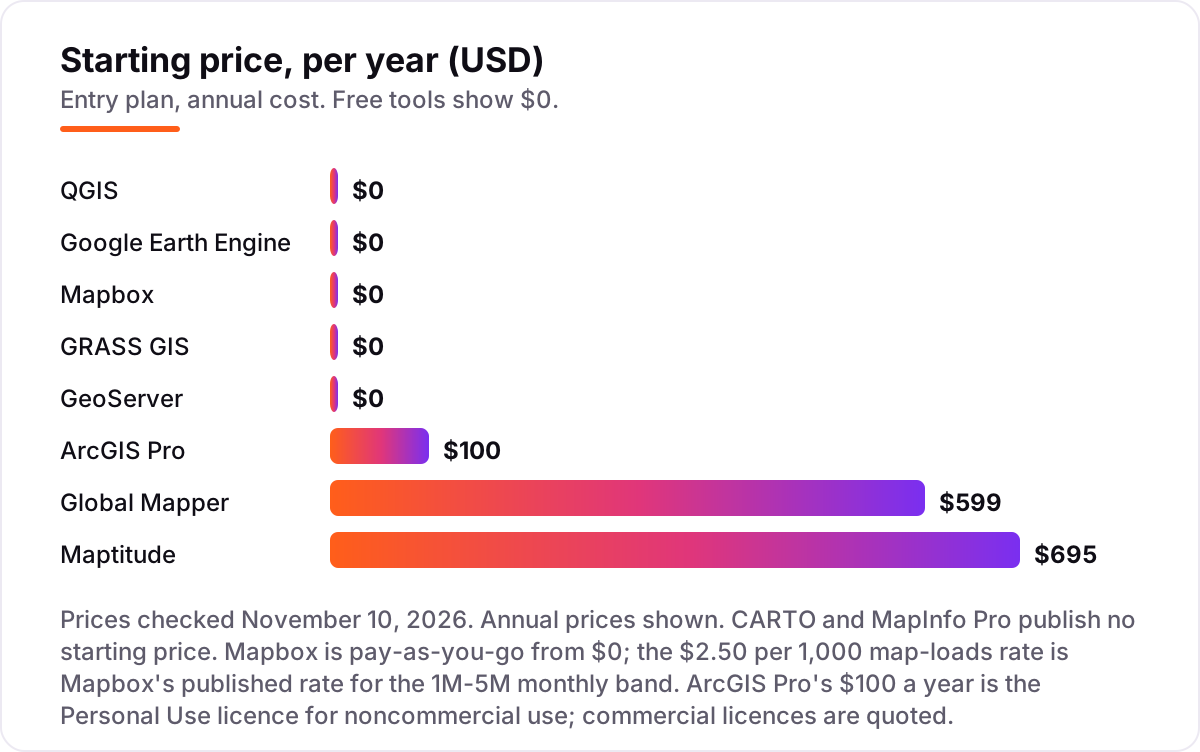
- Five of the ten tools cost nothing: QGIS, Google Earth Engine for noncommercial use, Mapbox on its free tier, GRASS GIS and GeoServer.
- The single most important buying factor is where the work happens: desktop GIS for analysis, cloud platforms for satellite data, and developer tools for maps inside apps.
- Two tools publish no price at all — CARTO and MapInfo Pro are quote-only — so budget a sales call for both.
- Every price below was checked on November 10, 2026. Ratings are G2, with review counts shown; five tools carry no rating because no G2 page was verified today.
On this page
Quick comparison
| Tool | Best for | Starting price | Free plan |
|---|---|---|---|
| QGIS | Anyone who wants a complete desktop GIS for free, from students to small consultancies | $0/yr | Yes (free) |
| ArcGIS Pro | Enterprise GIS teams and analysts who need the deepest analysis, 3D and Esri ecosystem integration | $100/yr (Personal Use) | No (21-day trial) |
| Global Mapper | Surveyors, engineers and analysts who convert, process and visualise LiDAR, terrain and dozens of file formats | $599/yr | No (14-day trial) |
| Google Earth Engine | Researchers, nonprofits and analysts who need planetary-scale satellite imagery without downloading it | $0/yr (noncommercial) | Yes (noncommercial) |
| Mapbox | Developers who need custom-styled interactive maps inside their own app or website | $0 (pay-as-you-go) | Yes (free tier) |
| CARTO | Data teams that analyse large location datasets in the cloud, beside their warehouse | Custom quote | No (free trial) |
| Maptitude | Business analysts who map sales territories, customers and demographics on Windows | $695/yr | No (30-day trial) |
| MapInfo Pro | Business and government teams on Windows who need desktop mapping tied to enterprise data | Custom quote | No (30-day trial) |
| GRASS GIS | Researchers and scientists who need serious raster and time-series analysis for free | $0/yr | Yes (free) |
| GeoServer | Teams that need to publish their maps as web services from their own server | $0/yr | Yes (free) |
Make one of these tools?
We re-check this list every quarter. Send a correction, request a review, or ask about a clearly labeled sponsored spot.
Request a listingThe best geospatial software

QGIS
Best for: Anyone who wants a complete desktop GIS for free, from students to small consultancies
QGIS is the obvious first download for anyone who needs a real GIS without a licence fee. It covers the full desktop workflow — creating and editing vector and raster data, running spatial analysis, building 3D views and producing print-ready maps — and it runs on Windows, macOS and Linux, so a mixed team can standardise on one tool. The plugin library extends it into field data collection, web publishing and specialist analysis.
The catch is support and polish. There is no vendor to call when something breaks: help comes from the community, documentation and third-party firms, and the interface can overwhelm a first-time user. If your team is comfortable learning from docs and forums, QGIS does the job of tools costing hundreds a year; if you need a support contract and training, price that in separately.
What we like
- Free and open source under the GNU GPL, with no licence fees at any team size
- Runs on Windows, macOS and Linux, and reads dozens of vector and raster formats
- A large plugin library extends it into 3D, web publishing, field data collection and more
Watch out for
- No vendor support contract is included — paid support comes from third-party firms, not the project
- The interface packs in so many tools that new users face a real learning curve
- Advanced analysis often needs a plugin, so quality varies between community extensions

ArcGIS Pro
Best for: Enterprise GIS teams and analysts who need the deepest analysis, 3D and Esri ecosystem integration
ArcGIS Pro is the commercial standard every other desktop GIS gets measured against. It handles the full workflow — mapping, editing and spatial analysis, plus 3D visualisation — and it shares logins, data and apps with ArcGIS Online and the Living Atlas, so Esri teams get one system. For learners, Personal Use is the cheapest way into professional GIS: ArcGIS Pro Basic, popular extensions, 200 service credits and Esri training.
The price is the problem for everyone else: Esri quotes commercial licences per organisation, so there is no budget number without a sales conversation, and the $100-a-year Personal Use licence is strictly for noncommercial projects. The desktop app is also Windows-only. Buy ArcGIS Pro when your organisation already runs Esri or needs its deepest analysis; otherwise QGIS covers most of the same work for nothing.
What we like
- The industry-standard desktop GIS, with 2D, 3D and 4D visualisation and deep spatial analysis
- Sits inside the ArcGIS system: ArcGIS Online, Living Atlas data and ready-to-use apps share the same login
- The Personal Use licence bundles ArcGIS Pro Basic, popular extensions, 200 service credits and Esri training
Watch out for
- Commercial licences are quoted by Esri — there is no published price for a business seat
- The desktop app runs on Windows only, so Mac and Linux teams need a workaround
- The Personal Use licence is for noncommercial projects only and cannot be used for client work

Global Mapper
Best for: Surveyors, engineers and analysts who convert, process and visualise LiDAR, terrain and dozens of file formats
Global Mapper is the utility knife of this list: a desktop GIS built for people drowning in file formats, terrain models and point clouds. It reads hundreds of spatial formats, converts between them without fuss, and handles terrain analysis and LiDAR processing that make QGIS users reach for plugins. The Essentials tier starts at $599 a year and covers core viewing, conversion and mapping, with support, updates and training bundled in.
Two things to check before buying. First, Blue Marble moved to subscriptions in September 2026, so a perpetual licence bought earlier no longer gains new features — new capabilities ship on subscription only. Second, the serious LiDAR, photogrammetry and AI classification tools sit on the $2,199-a-year Professional tier, not Essentials. For surveyors and engineers, that is still a fair price; for general mapping, QGIS is free.
What we like
- Reads hundreds of spatial file formats, so it converts and combines data other tools refuse
- Strong terrain modelling and LiDAR point-cloud processing on the higher tiers
- Annual subscriptions bundle support, updates and the full training library in one licence
Watch out for
- Subscriptions replaced perpetual licences in September 2026, and perpetual licences no longer gain new features
- LiDAR processing, photogrammetry and AI classification need the $2,199/year Professional tier
- Primarily a Windows desktop tool, with limited support for macOS and Linux

Google Earth Engine
Best for: Researchers, nonprofits and analysts who need planetary-scale satellite imagery without downloading it
Google Earth Engine solves a different problem from the desktop tools: analysing decades of satellite imagery without downloading any of it. The catalog holds petabytes of Earth observation data, and your code runs on Google's servers, so a continental land-cover analysis finishes in minutes instead of days. For academic research, education and nonprofits it is free, with a monthly quota of compute — 150 EECU-hours on the Community Tier — and a code editor plus JavaScript and Python APIs.
It is not a general-purpose GIS: there is no point-and-click editing, you write code, and commercial use is charged on usage-based compute pricing. If your work is satellite time series, deforestation, crop monitoring or climate analysis, nothing else in this list comes close; if you need to edit parcels and print maps, use a desktop GIS instead.
What we like
- A multi-petabyte catalog of satellite imagery and Earth observation data, analysed in Google's cloud
- Free for academic research, education, nonprofits and other noncommercial use
- Code Editor plus JavaScript and Python APIs, with a monthly quota of free compute for noncommercial projects
Watch out for
- Commercial and government operational use is paid, with usage-based compute pricing to work through
- It is a code-first platform (JavaScript and Python APIs), not a point-and-click desktop GIS
- Free noncommercial projects sit in a quota tier — 150 EECU-hours a month on the Community Tier

Mapbox
Best for: Developers who need custom-styled interactive maps inside their own app or website
Mapbox is for teams whose map is part of their product. Mapbox Studio lets you design every detail, and fast vector maps with 3D terrain render inside your app or website. Geocoding, directions and static images come from the same platform, and billing is pay-as-you-go: the free tier covers 50,000 web map loads a month, and Mapbox's published rate is $2.50 per 1,000 loads in the 1-million-to-5-million monthly band.
The pricing model is the thing to manage. There is no flat subscription to budget against, so a traffic spike or an autocomplete box firing on every keystroke can push the bill up without warning — debounce inputs and set usage alerts on day one. Mapbox also has no places database of its own. For branded maps inside a product, it is the default; for analysis, pick a desktop GIS.
What we like
- Mapbox Studio gives pixel-level control over map design, so maps match your brand
- Fast vector maps with 3D terrain, plus geocoding, directions and static-image APIs in one platform
- Pay-as-you-go with a free tier, so small products can ship real maps before paying anything
Watch out for
- Pure usage billing means a traffic spike or a misconfigured autocomplete box can raise the bill fast
- There is no built-in places database, so you bring your own location data
- Support plans are sold separately — individual support starts at $50 a month

CARTO
Best for: Data teams that analyse large location datasets in the cloud, beside their warehouse
CARTO is a cloud spatial-analytics platform, not a desktop GIS. It connects to the warehouse you already have — BigQuery, Snowflake or Databricks — and lets data teams run spatial SQL, build dashboards and publish interactive maps with Builder, without moving the data or writing front-end code. Basemaps are free up to 1 million commercial requests a month, and a free trial covers the platform itself.
The honest limitation is price transparency: the platform is sold as a custom annual agreement, so you cannot budget it without a sales conversation, and the real analysis work leans on SQL. Small teams that only need a map on a website will find Mapbox cheaper and simpler. CARTO earns its place when location data is large, lives in a warehouse, and several teams need to analyse it together.
What we like
- Cloud-native spatial analytics that runs beside BigQuery, Snowflake and Databricks
- Builder lets teams publish interactive maps without writing front-end code
- A free basemaps tier covers up to 1 million commercial requests a month before a paid plan is needed
Watch out for
- The analytics platform is quote-only — there is no self-serve price to budget against
- Real spatial analysis leans on SQL, so non-technical users face a learning curve
- Basemaps now need an API key, and commercial use above 1 million requests a month needs a paid basemaps plan

Maptitude
Best for: Business analysts who map sales territories, customers and demographics on Windows
Maptitude is a business-mapping GIS that ships with the data, not just the tools. Every licence includes a free country package of maps and demographic data down to Census Block Group level, and drive-time rings, geocoding, heat maps and territory management are built in rather than sold as add-ons. At $695 a year, it is the cheapest paid desktop GIS here, and it holds the highest G2 score at 4.7 out of 5.
Caliper's own pages quote both $695 a year and a $795 one-time purchase, so confirm which one you are buying before checkout. The software is also Windows-only, and the included demographic data is strongest for the US. For a sales, marketing or logistics team mapping territories on Windows, it is the value pick; for Mac teams, QGIS is the free answer.
What we like
- Ships with a free country package of maps and demographic data down to Census Block Group level
- Drive-time rings, geocoding, heat maps and territory tools are built in, not add-ons
- The highest G2 score in this list at 4.7 out of 5, with reviewers citing value for money
Watch out for
- Windows-only desktop software, so Mac-based teams need another tool
- Caliper's own pages quote both $695 a year and a $795 one-time purchase — confirm which applies before buying
- Demographic data ships as country packages, and the 2026 package costs $695 for existing users

MapInfo Pro
Best for: Business and government teams on Windows who need desktop mapping tied to enterprise data
MapInfo Pro is the veteran of business mapping: a Windows desktop GIS that has served telecom, utilities, retail and government teams for decades. One- and three-year subscriptions include maintenance, updates and the raster and visualisation features formerly sold as the Advanced edition, and it handles the full workflow from data creation and editing to thematic maps and location intelligence. A 30-day trial lets a team test it on real data.
Its weakness is transparency. Precisely publishes no price, so every licence starts with a sales quote, and the community around it is far smaller than QGIS or ArcGIS Pro — fewer tutorials, fewer plugins, fewer people to ask. Choose MapInfo Pro when your organisation already runs on MapInfo data and workflows; starting fresh, QGIS or Maptitude gives you a price you can actually budget.
What we like
- Long-established desktop GIS for business mapping, spatial analysis and location intelligence
- One- and three-year subscriptions include maintenance, updates and the features formerly sold as Advanced
- Strong in telecom, utilities and retail, where teams already hold MapInfo data and workflows
Watch out for
- Precisely publishes no price — every licence is a sales quote, so budgeting takes a call
- Windows-only desktop software with a smaller community than QGIS or ArcGIS Pro
- Advanced raster processing sits in the higher Advanced and Premium licence tiers

GRASS GIS
Best for: Researchers and scientists who need serious raster and time-series analysis for free
GRASS GIS is the research engine of open source GIS: a suite of more than 400 analysis modules for raster, vector, imagery and time-series work, with a built-in temporal framework and a Python API for modelling and automation. It runs on Windows, macOS and Linux, is free under the GNU GPL, and is the longest-maintained open source GIS available. Scientists use it where the analysis itself is the job.
It is not the friendly face of GIS. The interface feels dated next to QGIS, much of its power sits behind the command line, and there is no vendor support — help comes from the community and the documentation. Most teams should start with QGIS and reach for GRASS when an analysis needs its modules.
What we like
- More than 400 built-in analysis modules for raster, vector, imagery and time series
- A built-in temporal framework and Python API for advanced modelling and automation
- Free and open source under the GNU GPL, and the longest-maintained open source GIS available
Watch out for
- A steep learning curve — the interface and workflow feel dated next to QGIS
- Much of its power sits behind the command line and a module system that takes time to learn
- No vendor support; help comes from the community and documentation

GeoServer
Best for: Teams that need to publish their maps as web services from their own server
GeoServer finishes the workflow the other tools start: it publishes your spatial data as standard web services that any map client can consume. It implements the OGC standards — WMS for map images, WFS for features — so QGIS, Leaflet and other clients can all read from the same source. It is free and open source, it runs on your own server under your own branding, and OpenLayers is integrated for quick map previews.
GeoServer is a server, not a desktop GIS: there is no map editing or spatial analysis inside it, and setup, security and hosting need someone technical — plus a Java server with real resources. Pair it with QGIS for editing and you have a complete publish-your-maps stack for the price of hosting alone, which is why it closes this list.
What we like
- Publishes maps and data as standard OGC web services (WMS, WFS) that any client can consume
- Self-hosted, so the maps live on your domain under your branding
- OpenLayers is integrated, so basic map previews work straight out of the box
Watch out for
- It is a server, not a desktop GIS — there is no built-in map editing or analysis
- Setup and hosting need technical skill, and it runs on Java, so it wants real server resources
- No vendor support contract is included; paid support comes from third-party firms
Best geospatial software is not one product: it is a desktop GIS for analysis, a cloud platform for satellite data, or a developer toolkit for maps inside an app, and the right pick depends on which of those jobs you are hiring for. This list ranks ten options by fit for the most common buyer — a small team that needs real analysis without an enterprise budget — with every price checked on November 10, 2026.
Five of the ten cost nothing, two publish no price at all, and the most expensive published starting price here is $695 a year. Start with the comparison table below, then read the card that matches your job.
Quick comparison: tool type by need
| Buyer | Best pick | Why |
|---|---|---|
| Solo analyst on a budget | QGIS | $0, a full desktop GIS on any operating system |
| Enterprise GIS team | ArcGIS Pro | Deepest analysis and the Esri ecosystem |
| Surveyor or engineer with LiDAR | Global Mapper | Terrain and point-cloud tools from $599 a year |
| Researcher working with satellite data | Google Earth Engine | Petabyte-scale imagery, free for noncommercial use |
| Developer embedding maps in an app | Mapbox | Custom styling, pay-as-you-go from $0 |
| Data team with a cloud warehouse | CARTO | Spatial analytics beside BigQuery and Snowflake |
| Business analyst mapping territories | Maptitude | Demographic data included from $695 a year |
| Windows team with MapInfo history | MapInfo Pro | Established business GIS, sold by quote |
| Scientist needing heavy raster analysis | GRASS GIS | 400-plus analysis modules, free |
| Team publishing maps as services | GeoServer | OGC web services, self-hosted, free |
How to choose the best geospatial software for your team
- Start with the job, not the brand. Analysis means a desktop GIS, satellite time series means a cloud platform, and maps inside an app mean a developer toolkit. Buying the wrong category is the most expensive mistake in this list.
- Check the operating system. ArcGIS Pro, Maptitude and MapInfo Pro are Windows-only desktops; QGIS and GRASS GIS run on Windows, macOS and Linux, and the cloud tools run anywhere with a browser.
- Count the real cost per user per year. Licences are per seat, so multiply before you compare — and add hosting for GeoServer and usage charges for Mapbox and commercial Earth Engine.
- Check the formats you actually use. If your work lives in LiDAR, CAD or dozens of odd formats, Global Mapper earns its price; if it is shapefiles and GeoTIFFs, QGIS is enough.
- Try the free route first. QGIS for editing and analysis plus GeoServer for publishing covers most small-team needs for $0 in licences.
- Confirm the licence covers your use. Personal Use and noncommercial tiers cannot be used for client work, so read the terms before you build a business on a free tier.
Before you publish location pages for the areas you map, run your titles through the free SERP snippet preview tool — it shows exactly how the title and description will look in Google.
Geospatial software pricing: what you will actually pay
Take a three-person team. On QGIS they pay $0 a year in licences. On Global Mapper Essentials they pay $1,797 a year (3 × $599). On Maptitude they pay $2,085 a year (3 × $695). Add one ArcGIS Pro commercial seat and the total becomes a quote, not a number — budget a sales call, and remember the $100-a-year Personal Use licence cannot be used for that work.
Usage-based tools change the maths again. A Mapbox app starts at $0 and only bills for map loads above the free tier, while a team that only publishes maps can skip licences entirely: GeoServer costs $0 and the only bill is hosting. The cheapest stack in this list — QGIS plus GeoServer — costs a small team nothing but hosting, which is why it is the default recommendation for budget buyers. For a deeper look at mapping for property work, see our guide to the best mapping software for commercial real estate.
Desktop GIS vs cloud mapping: know the difference
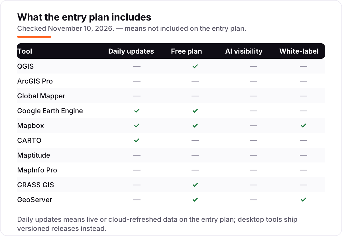
The biggest confusion in this category is the word "GIS" itself, because it now covers three different jobs. Desktop GIS — QGIS, ArcGIS Pro, Global Mapper, Maptitude, MapInfo Pro and GRASS GIS — installs on your computer, works with local files, and charges per seat per year. You own the files, you control the versions, and you can work offline.
Cloud mapping — Google Earth Engine, CARTO and Mapbox — runs in a browser or an API, scales to datasets no desktop could hold, and bills by usage. You never install anything, but you never fully own the bill either: it moves with traffic and compute. GeoServer is the third shape: a server you host yourself, publishing your maps as standard web services under your own branding.
The practical rule is simple. If the work is analysis, editing and printed maps, buy a desktop GIS. If the work is satellite data at scale or maps inside a product, use a cloud platform. If the work is publishing maps your users already consume, host GeoServer. Mixing the categories up — buying a desktop GIS to serve web maps, or a usage-billed API to do parcel editing — is how teams end up paying twice. Our best geo tools for ecommerce guide covers the location-tool side of the same decision.
How we chose
We checked each vendor's own pricing page on November 10, 2026 and recorded the starting price exactly as shown, as an annual figure — free tools show $0 a year, and the two quote-only tools, CARTO and MapInfo Pro, are listed as custom quote. Three figures need a note. Esri publishes no commercial price for ArcGIS Pro, so the $100-a-year Personal Use figure comes from Esri's own community pages and directory listings, not from Esri's overview page, and it covers noncommercial use only. Mapbox's free tier of 50,000 web map loads a month comes from an October 16, 2026 check of Mapbox's own pricing page, because the live crawl of mapbox.com/pricing returned support plans only; the $2.50 per 1,000 map-loads rate is from Mapbox's own blog. Caliper's own pages quote both $695 a year and a $795 one-time purchase for Maptitude, so we lead with the $695 subscription and flag the conflict in the card. Ratings come from G2 compare pages crawled within the last three days, with review counts shown; five tools carry no rating because no G2 page for them was verified today. We ranked by fit for the most common buyer — a small team needing real analysis without an enterprise budget — not by brand size, and no vendor paid for a place in this list. If your maps feed a local business, our local SEO service is built around exactly this kind of location data, and the best AI data analytics tools guide covers the analysis side.
What to do next
Start with the decision in the "How to choose" section above: name the job, check the operating system, and count the real per-seat cost. Then install QGIS and run your own data through it for a week — if it does the job, you may never need to pay. If it does not, take the free trial of the paid pick that matches your job and test it on the same files. Once your tools are in place, find out what's holding your rankings back.
Your stack only works if people find you
SerpAstra fixes what keeps your site off page one and makes it easy for AI assistants to recommend.
Get a free audit→Sources we checked (19)
- QGIS download — qgis.org/download (checked November 10, 2026)
- QGIS on G2 — 4.5/5, 154 reviews (checked November 10, 2026)
- ArcGIS for Personal Use — esri.com overview (checked November 10, 2026)
- ArcGIS Pro — esri.com product overview (checked November 10, 2026)
- Global Mapper pricing — bluemarblegeo.com/purchase; tiers per Blue Marble subscription FAQ (vendor FAQ crawled November 8, 2026)
- Global Mapper subscription FAQ — Blue Marble (Essentials $599/year, checked November 10, 2026)
- Global Mapper on G2 — 4.3/5, 30 reviews (checked November 10, 2026)
- Google Earth Engine noncommercial tiers — developers.google.com (checked November 10, 2026)
- Mapbox pricing — mapbox.com/pricing (checked November 10, 2026)
- Mapbox map-load pricing — Mapbox blog, $2.50 per 1,000 loads in the 1M-5M band (checked November 10, 2026)
- Mapbox free tier — 50,000 web map loads a month, checked against Mapbox's pricing page October 16, 2026
- CARTO on G2 — 4.5/5, 78 reviews (checked November 10, 2026)
- CARTO pricing — G2 (enterprise plans by quote, checked November 10, 2026)
- Maptitude pricing — caliper.com (Desktop Subscription $695/year, checked November 10, 2026)
- Maptitude on G2 — 4.7/5, 150 reviews (checked November 10, 2026)
- MapInfo Pro — precisely.com product page (checked November 10, 2026)
- MapInfo Pro on G2 — 4.1/5, 120 reviews (checked November 10, 2026)
- GRASS GIS — grass.osgeo.org (free and open source, checked November 10, 2026)
- GeoServer — geoserver.org (free and open source, checked November 10, 2026)
Shamim
Founder of SerpAstra
A full-stack SEO and digital marketer who spends most days on Local SEO for dental practices, AI search visibility and lead generation.
Frequently asked questions
What is the best geospatial software in 2026?
QGIS is the best free option: a complete desktop GIS for $0. ArcGIS Pro is the enterprise standard for deep analysis and 3D, and Global Mapper is the best paid desktop pick at $599 a year. If your end product is a map inside an app, Mapbox matters more than any desktop GIS here.
How much does geospatial software cost?
From $0 to $695 a year for the tools that publish a price: QGIS, GRASS GIS, GeoServer and Google Earth Engine (noncommercial) are free, Global Mapper starts at $599 a year and Maptitude at $695. ArcGIS Pro, CARTO and MapInfo Pro publish no commercial price — all three are sold by quote.
Is there free geospatial software?
Yes, and it is genuinely capable. QGIS is a full desktop GIS, GRASS GIS is a research-grade analysis suite, GeoServer publishes web maps, and Google Earth Engine is free for noncommercial use. Mapbox also has a free usage tier. Free tools cover most small-team needs; you pay when you need vendor support or enterprise scale.
What is the difference between desktop GIS and cloud mapping software?
Desktop GIS (QGIS, ArcGIS Pro, Global Mapper) installs on your computer, works with local files and charges per seat. Cloud mapping (Google Earth Engine, CARTO, Mapbox) runs in a browser or API, scales to huge datasets and bills by usage. GeoServer sits between them: you host it, and it publishes your maps as web services.
Can I use QGIS instead of ArcGIS Pro?
For most mapping, editing and analysis work, yes — QGIS handles the same formats and workflows for free. ArcGIS Pro wins when your organisation already runs Esri infrastructure, needs its deepest 3D and geoprocessing tools, or requires a vendor support contract. Many teams run both: QGIS for day-to-day work, ArcGIS Pro for enterprise projects.
What should I check before paying for geospatial software?
Four things: whether the licence is a subscription or a one-time purchase, and what happens at renewal; whether it runs on your team's operating system; whether it reads the formats you actually use, including LiDAR and CAD; and whether the trial covers your real data. Always test with your own files before signing a quote.
Do I need to pay for satellite imagery analysis?
Not for noncommercial work. Google Earth Engine is free for academic research, education and nonprofits, with a monthly compute quota of 150 EECU-hours on the Community Tier. Commercial and government operational use is charged on usage-based compute pricing, so get a quote before building a product on it.
Free SEO and AI visibility audit
Find out what is holding your rankings back
Send us your site. Within 2 business days you get a written audit, an AI visibility check and a short fix list ranked by impact. Free, with no contract attached.
Request my free audit→Related guides
 Local Business & Vertical Software9 Best Mapping Software for Commercial Real Estate in 2026, ComparedCompare the 9 best mapping software for commercial real estate on price, demographics, foot traffic and free plans, with every price checked November 8, 2026.Read guide →
 SEO & AI Search8 Best GEO Tools for Ecommerce in 2026 (Free and Paid, Compared)The 8 best geo tools for ecommerce, compared on price, AI engines, SKU tracking and free trials. Every price checked on the vendor page, November 1, 2026.Read guide →
 IT, Security & DevOps11 Best AI Data Analytics Tools in 2026 (Free and Paid, Compared)Compare the 11 best ai data analytics tools on price, free plans, credits and AI features, ranked by use case, with every price checked November 6, 2026.Read guide →